Kanab: Base Camp to Southern Utah | Rock Art of the Grand Staircase
Sunday – Thursday, May 3-7, 2026
To this great wall, terminating the Triassic terrace and stretching from the Hurricane Ledge to the Paria, Powell has given the name of The Vermilion Cliffs. Their great altitude, the remarkable length of their line of frontage, the persistence with which their proportions are sustained throughout the entire interval, their ornate sculpture and rich coloring, might justify very exalted language of description.
After driving all the way across the Arizona Strip on Friday and spending the remainder of the weekend exploring the Sand Hills on top of the Paria Plateau, I drove back over the northern end of the Kaibab Plateau on Sunday afternoon and made my way down to Kanab at the base of the Vermilion Cliffs to spend the rest of the week attending the 2026 UGIC Conference for work. It’s been quite a while since I last spent much time in the landscape surrounding Kanab and there were quite a few rock art sites and other short hikes that I’ve wanted to check out, so I was planning to visit as many of these sites as I could during the week when I wasn’t busy at the conference. Luckily, I was able to find plenty of time for a few sandy drives and short hikes either before or after the conference each day and was able to find most of the sites that I was looking for this week, plus a couple extras along the way! These are just some photos from my week exploring the the cliffs at the base of the Grand Staircase.
After checking into my hotel on Sunday afternoon I headed out to finally check out the Clam Shell Petroglyph Site which has been on my to-do list for over fifteen years, so I was finally glad to cross it off! Of course, an incoming storm arrived right after I made it to the site and the strong winds and rain quickly chased me back down to the car.

Clam Shell Petroglyphs


While I have driven by Pipe Springs National Monument many times before, I’ve never made the time to stop there, so I figured this would be a great opportunity to finally do that.

Pipe Spring Wagon

It’s a small Monument and there aren’t many hiking trails, so I made sure to hike all of them while I was here.

East Cabin & Corral

Winsor Castle Door

Winsor Castle

Winsor Castle Courtyard

It was a little tricky to find a route to this next set of petroglyphs, but I was eventually able to find a sandy and rough road that got me close.

Desert Varnish Panel

Four Arms Panel

Big Corner Panel


This figure is missing a leg.

Big Sheep Panel

Block Head

Squiggles Panel

At the head of the canyon I climbed up into a big alcove behind this boulder to find a few pictographs.

Outline Guy

I was happy to find a little time to revisit this interesting pictograph site.


I ventured into the White Cliffs to find these interesting petroglyphs.


Three & Four Fingers

Snake Panel

White Lines

Exploring two-tracks below the White Cliffs.

Boulder Grooves & Designs

There were some nice large petroglyphs of sheep and elk at this site, but they were vary hard to see and photograph.


This small alcove contained some interesting pictographs.


Dotted Headdress

Eagle Gate Arch

Superman Site

Outline Pictographs

I passed by a few waterglyphs throughout the week.

Rosy Canyon Cliffs

Coral Pink Sand Dunes & Moquith Mountains

I had a few extra hours one morning before I needed to be at the conference, so I took a drive out to Gunsight Point for a massive view over the Kanab Creek Wilderness.

Snake Gulch comes in from the left and joins Kanab Creek below.

One day when I was at the conference until later in the afternoon I went for a short hike on the local Kanab Trails at the edge of town.

Vermilion View

Little Hole

Kanab Overlook

Kanab Trail

There was even a little faux waterfall along the Raven Trail.

Stone Design

I hiked up to the dinosaur tracks just north of town.


I spent a warm afternoon searching for the petroglyphs in the Raven’s Crack. This was the wrong crack…

The Guardian

Raven’s Crack Petroglyphs


It took me a while longer than I had hoped, but I eventually found the panel I was looking for!

Double-Header


My final hike of the week was up the Mansard Trail.

Walking along a nice colorful wall before entering the alcove with the petroglyphs.

The most interesting part of this site are the long grooves carved into the sloping floor of the alcove.

Grooves & Petroglyphs

Bow Hunter


Here is one final view of the Vermilion Cliffs as I hiked down from the Mansard Petroglyph Site.

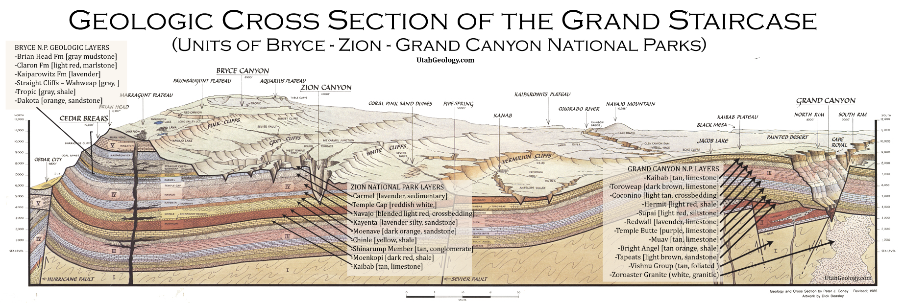
If we proceed southward from the district of the High Plateaus of Utah, we shall gradually descend from an altitude of more than 10,000 feet to one of less than 5,000 feet. The country thus traversed is terraced off in a succession of steps, each terrace being terminated by a sinuous line of cliffs or abrupt slopes. Each cliff is the limiting border of a great series of strata, no member of which is encountered again for an indefinite distance to the southward. As we descend each cliff we find ourselves at its base upon the summit of a lower series.
Wow wow wow – so many interesting panels. Thank you for sharing all of this!
Thanks Janice!