Beyond the High Plateaus: The Tertiary History of the Grand Canyon District, Part II
Saturday – Sunday, May 2-3, 2026
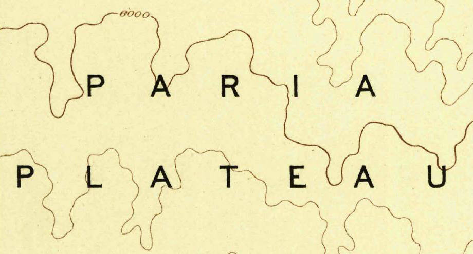
The platform between the Echo Cliffs and the Kaibab possesses some features which merit a brief notice. It is divisible into two subordinate portions. Upon the north of it is an extension of the Triassic formation, which forms a terrace of considerably greater altitude than the remaining portion. The southern portion has for its surface the Carboniferous formation and contains the Marble Canon. The Triassic portion has received the name of the Paria Plateau, and the other has throughout this work been called the Marble Canon platform.
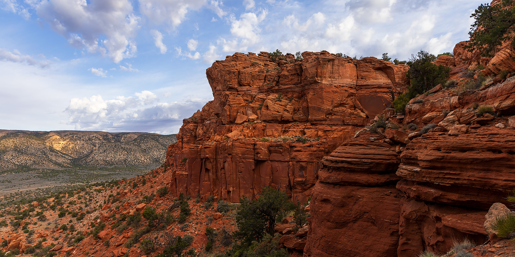
After spending all day Friday driving across the Arizona Strip, I was up bright and early on Saturday morning to watch the sunrise from the edge of Marble Canyon and then drove up House Rock Valley along the base of the Kaibab Plateau to the western end of the Paria Plateau so I could spend the rest of the weekend exploring the Sand Hills on top. Aside from an amazing backpacking trip through Paria Canyon last spring, I have not been back to explore the Paria Plateau since 2019, which is a shame because it’s a place I used to enjoy visiting at least once almost every year, and sometimes many more times than that! As you can imagine, I was really looking forward to finally returning! After driving up onto the plateau via the Bonal Springs Road I spent the rest of the day following twisty, sandy, two-track roads that roughly followed the southern and western rims of the plateau while also stopping frequently to get out to hike and explore along the way.
At my first stop I took a short walk over to the edge of the plateau where I had a view over the vast Marble Platform to the distant Kaibab Plateau.

There were quite a few stone ruins found in this area.

These are the remains of a pretty long wall.

I stopped to visit the old Jarvis Ranch House and other structures found nearby.


Walking around inside the old ranch house.

Next, I went searching for a crack through the Vermilion Cliffs at the edge of the plateau…

I found the crack and started hiking down, but turned around after a couple hundred feet because it got too steep and loose for me.

Crack Tower

I did find a few faded petroglyphs nearby.


Claret Cup

Not long afterwards I went searching for another crack through the side of the plateau.

Sand Hills Arch

This crack was not as steep and had a pretty good trail through it.

There were quite a few petroglyphs in this area, but they were all pretty hard to see and photograph, especially in the direct sunlight of the early afternoon.


There were some nice petroglyphs in this corner.

These were probably my favorite figures.


Hiking back up through the crack.

While I was out exploring the top of the Paria Plateau I figured that I should probably visit the highpoint since it’s the only plateau highpoint Jared and I did not visit during our Peaks & Plateaus trip across the Arizona Strip about a year and a half ago.
Following the top of the Vermilion Cliffs along the western edge of the Paria Plateau.

There was a good view across the Marble Platform to the Echo Cliffs with the gash of Marble Canyon and Tanner Wash seen below.


My first stop was at the Mar Benchmark (7,355), but all I could find was the old survey cairn.

As I was leaving the area I did find this Reference Marker pointing back towards the cairn.

The actual highpoint of the Paria Plateau (7,356) is located three-tenths of a mile further north and is only one foot higher. I found this cairn at the highpoint.

While following an old closed road in search of some mesa-top ruins I spotted this projectile point sticking out of the sand.

This site on top of the mesa was pretty extensive.


My final stop of the day was at these nice red pictographs.

At this point I realized I was going to need to get gas since I didn’t bring my extra jerry cans along this time, so I decided to drive down off the plateau and head up to Jacob Lake for fuel and dinner before it got too late.
I passed by the Condor Viewing Site in the Vermilion Cliffs as I made my way back through House Rock Valley to the highway.

After eating dinner and leaving Jacob Lake I returned to House Rock Valley and found a campsite after dark. It had been a long day and I was tired, so I fell right asleep.
The Paria Plateau presents some very instructive considerations in connection with the recession of cliffs. To appreciate them it is necessary to glance at the structural, topographic, and stratigraphic relations. An examination of the map will show that this plateau consists of a mass of Triassic beds which project far beyond the main line of the Vermilion Cliffs. At the village of Paria the main front of the Vermilion Cliffs terminates abruptly. The marginal line of the Triassic formation here changes its trend, running southward along the Kaibab wall for a distance of nearly 30 miles; then swinging easterly in a large semicircle reaches the Colorado at the head of the Marble Canon. In this semicircle the Triassic Cliffs are the exact counterpart in all respects of the main Vermilion Cliffs west of Paria village; only the line of frontage has for some reason been left far in advance of the main line.
On Sunday morning I was up with the sunrise and watched the sun light up the mouth of Burro Canyon as I hiked up to Vermilion Arch.

Vermilion Arch

There were actually some nice clouds in the sky this morning as I explored the eastern rim of the Paria Plateau.

Faded Petroglyphs

I went on a very sandy walk to see Double Barrel Arch.

There was a lot of driving on sandy two-tracks this weekend!

I wandered around the Red Pocket for a little while.


Then I revisited these faded petroglyphs that are located in a little slot.


Wire Grass Sandstone

Before driving back down off the Paria Plateau I wandered around another red pocket of sandstone up on a ridge.


On the Paria Plateau not a solitary channel carries a living stream except the Paria River, which receives its supply of water from the much loftier and moister region of the High Plateaus far to the northward. The extinct channels flow into it, and have directions which are very plainly determined by the general dip of the Paria table, which is towards the northeast.
Once the afternoon rolled around it was time for me to start making my way over to Kanab, where I would be attending a conference for the remainder of the week, so I followed the Winter Road over the northern end of the Kaibab Plateau on my way to Fredonia.

There was a nice distant view of the Grand Staircase as I descended from the plateau, which is where I would be spending the rest of the week exploring, when I wasn’t busy at the conference…

Love it, Randy! As always, wonderfully well done! I enjoyed the C.E. Dutton inserts. I’ve been up on the Paria Plateau about ten times, including twice out to the ends of tracks east of White Pocket. I also hiked up the Sand Hill Crack from the bottom to the top eight years ago and saw all those interesting petroglyphs. Last year I drove out to a couple of remote Paria Canyon viewpoints on the east side. Sadly, I turn 75 this summer, and it’s clear my rugged hiking days are numbered! All the best, John Spurr
Nice. Love the projectile point.
At 73 my rugged hiking days are mostly behind me too, but I enjoy your adventures vicariously. Carry on!