Across the Arizona Strip | Friday – Saturday, May 1-2, 2026
During the seasons spent in the study of the High Plateaus I had found the temptation irresistible to wander far outside of the limits of my prescribed field; and whither should the errant geologist turn his footsteps so eagerly as towards the wonder-land of the south? And so, when the early snows and biting winds of autumn drove us out of the lofty volcanic regions of the north, the remaining weeks of each year were spent in rapid excursions through the milder regions, which lie beyond the foot of the great stairway of terraces which leads down from the heights of the Markagunt.
After spending Thursday evening in Las Vegas I was up extra early on Friday morning and ready to leave Nevada for a long, hot and dusty drive across the Arizona Strip. I’ve always wanted to enter the Arizona Strip from the west via Gold Butte National Monument and figured this would be a good time to finally do it. I planned to drive all the way across the Arizona Strip to the Marble Platform on the eastern end which would give me the opportunity to see more of the Plateau Province that I started exploring more thoroughly back in 2024. After topping off my gas tank in Moapa for the long drive ahead, I followed the Virgin River to Whitney Pocket at the southern end of the Virgin Mountains and began my trek eastward.
It was a beautiful morning in Gold Butte National Monument and it’s kind of hard to believe I haven’t been back here in over six years! I need to come back for a proper visit soon.

Dappled light at the edge of the Virgin Mountains.

Whitney Pocket Morning

I did stop to search for a few petroglyphs that I had missed seeing during previous visits.


Whitney Pocket

Mojave Morning

I passed by this small arch as I started driving east.

Following the road past Quail Point on my way up to Whitney Pass.

Whitney Pass & Billy Goat Peak

On the other side of Whitney Pass I entered Arizona and Grand Canyon – Prashant National Monument as I descended into Pakoon Basin.

I took a short detour to hike the Pakoon Springs Trail, which doesn’t seem to get much use.

The vegetation was thick and green around Pakoon Springs.

There were plenty of Joshua Trees in Pakoon Basin.

As I drove up onto the ridge on the other side of the basin there was a great view over Pakoon Basin to the Virgin Mountains.

I followed the road along Pocum Wash into Black Canyon which took me around the northern end of the Grand Wash Cliffs just before starting to climb back up onto the Colorado Plateau via Road Canyon- leaving the Mojave Desert behind.

Once I was back up on the Colorado Plateau I followed a few different roads that took me across the Wolf Hole Valley, Main Street Valley, Lower Hurricane Valley and Rock Crossing. Then the road climbed steeply through the Hurricane Cliffs and crossed The Black Rocks until I eventually reached the paved highway near Cottonwood Point and followed it over to Fredonia, where I stopped to get gas. From there I continued along the highway to Jacob Lake on the Kaibab Plateau and then dropped down onto the Marble Platform.
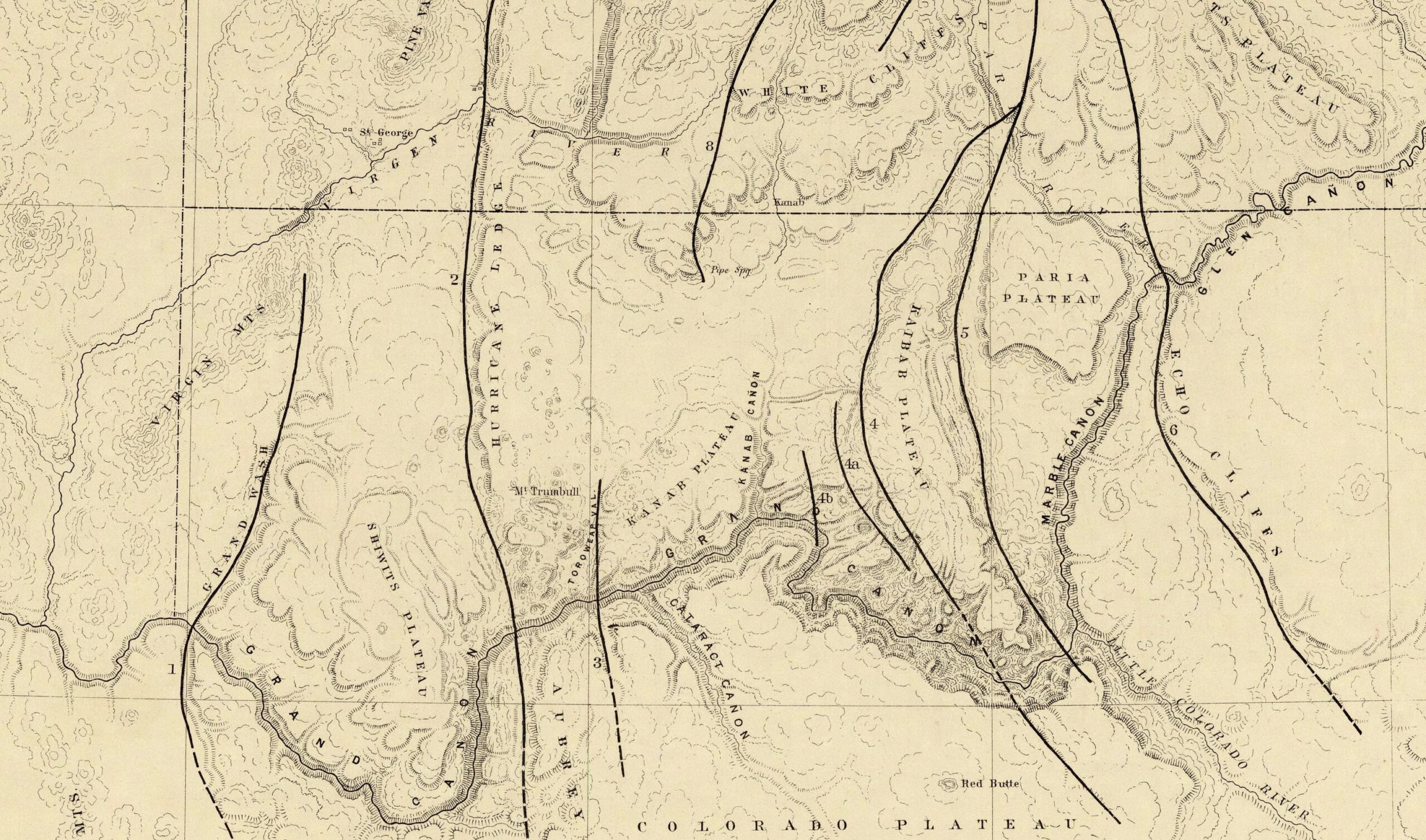
The Marble Cañon platform presents but few considerations, and those of the most patent kind. Like the Grand Cañon platform, it consists of Carboniferous strata, with a considerable number of Permian remnants scattered over it. The same northward dip of 50 to 100 feet per mile is everywhere noticeable, and has the same relative importance, because of the great distance over which it prevails. The great feature of the platform is, of course, the Marble Cañon. If the Grand Cañon were not hard by, and if its wholly incomparable magnitudes and grandeur did not belittle everything with which we might think of comparing it, the Marble Cañon might be the theme of some enthusiastic description. Though far inferior to the Grand Cañon, it surpasses all others in the grandeur and power of those features which are the exclusive attributes of cañon scenery.
As I drove down from the Kaibab Plateau to the Marble Platform I had a great view of clouds building over the Paria Plateau.

After stopping for dinner at the Cliff Dwellers Restaurant I explored some of the roads at the northeastern end of the Marble Platform around Badger Creek and Soap Creek.

Looking down Marble Canyon from the confluence with Badger Canyon.

There were quite a few purple Claret Cups blooming in this area.

I found a good view of Badger Creek Rapid and watched a few rafts go through. If you look closely, you can see a raft just near the tail-end of the rapid.

Paria Plateau Point

Although I’ve driven by many times, this was the first time I stopped to look at the Stone House at Cliff Dwellers.

It was starting to get late, so it was finally time to drive across House Rock Valley to find a campsite along the rim of Buck Farm Canyon.

I stopped to check out the top of the trail that descends into South Canyon.

I also visited the Nankoweap Trailhead near Saddle Mountain.

Saddle Mountain

Waterglyphs have never really piqued my interest, but since I was in the area I figured I’d go look for this one since it’s in an awesome setting.

Hiking out on a narrow peninsula that juts out into Buck Farm Canyon.

Following a crooked road in search of a campsite.

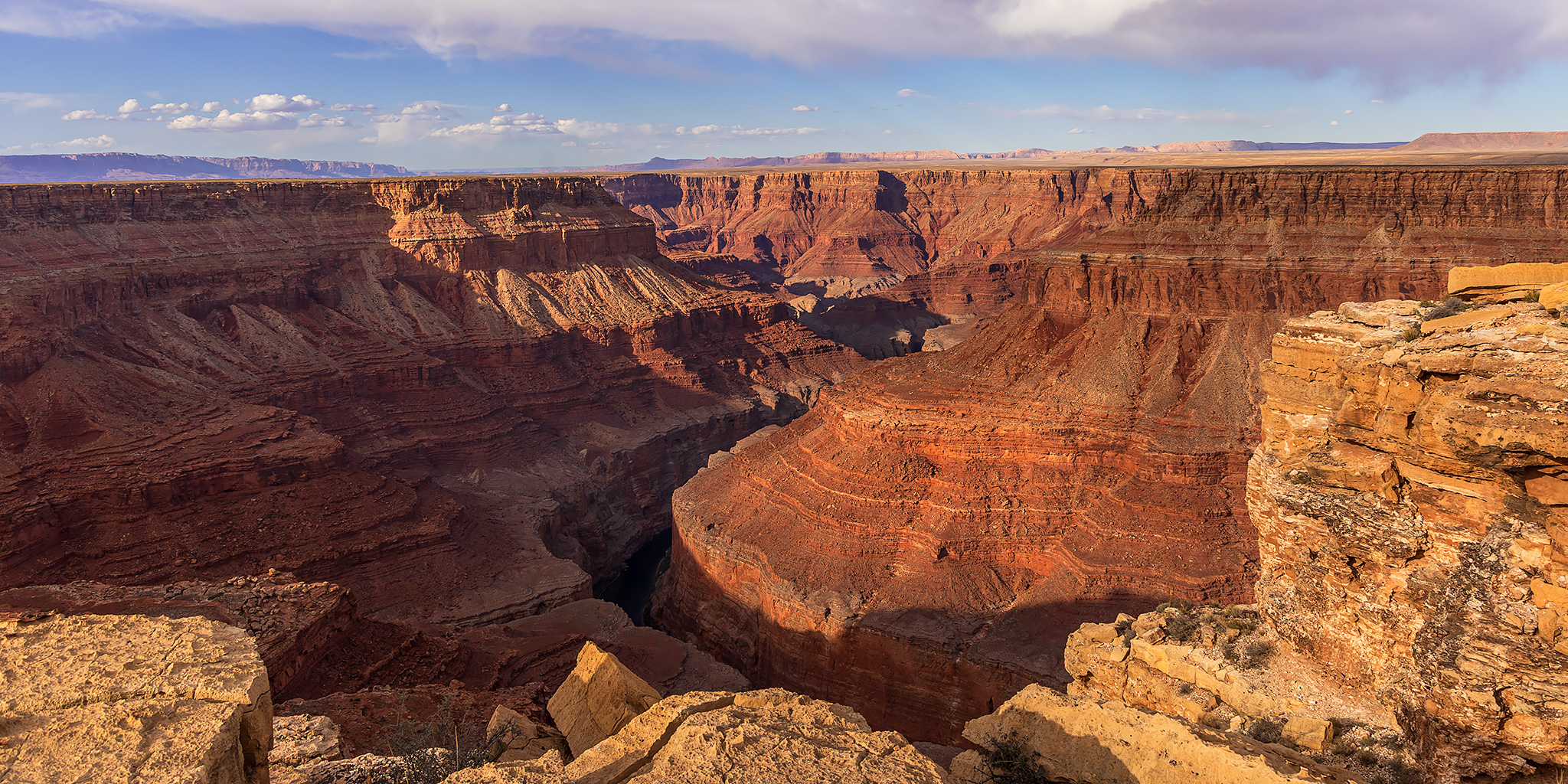
I found a campsite with an amazing view of Marble Canyon and the sky was looking pretty nice this evening.

Marble Canyon Overlook

This is the view downstream toward Point Hansbrough.

It was not a bad place to watch the sunset and spend the night…

The Echo Cliffs were on the horizon to the east, including Antelope Pass.

Light On the Rim

Looking down to the confluence of Marble Canyon and Buck Farm Canyon at dusk. I spent a night down there last year on our river trip.

Marble Canyon at Dusk

I was up early on Saturday morning and got to watch the Flower Moon disappear behind the Kaibab Plateau above Buck Farm Canyon.

Marble Canyon Morning

Once the sun was up I drove back across the House Rock Valley on my way to spend the rest of the weekend on the Paria Plateau.

What a fabulous trip! Some interesting places we may add to a future Gold Butte trip planned for next year.
We are looking forward to our fall UT red rock trip!
Thanks for sharing. Really like your adventures.
Thank you Lisa!
Great photos. I was there with my father-in-law about two weeks after you were, on a side trek of a trip from Tucson to Durango. Did you get to see any condors?
No, I did not see any condors this time.