 Ever since the Department of the Interior upgraded and redesigned the Bureau of Land Management (BLM) website last year, it has been difficult to locate the official BLM Travel Management Maps that I’ve used for years. I have decided to create this page with links to the current Travel Management Maps for the Monticello BLM Field Office so they might be easier for everyone to find with a simple search. These are the official maps that show which roads and trails are open to motorized travel and they make a great reference for planning trips to this beautiful part of southern Utah. Just a reminder- Any road or trail that is not shown on these maps are not designated for motorized travel! The BLM updates these maps quarterly, so make sure you check back to see if they have been updated before your next trip.
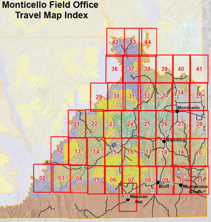
The easiest way to get started with these maps is to download the Travel Plan Maps Index first, which will show you an overview of the area with a numbered grid over the map. I have also included an image of this Map Index toward the bottom of this page, just scroll down to see it. The numbers on that grid will let you know which of the other maps below you will need to download. I hope you find these links useful! If you do, please consider Sending a Donation to ADVENTR.co
Also, don’t forget that I have plenty of popular (and not so popular) GPS Tracks from the Monticello vicinity available on my Utah GPS Tracks page!
If you find that any of the links below are broken, please let me know in the comments so I can update them.
Travel Management Maps Index
Monticello Travel Management Maps
- Travel Plan Map 1
- Travel Plan Map 2
- Travel Plan Map 3
- Travel Plan Map 4
- Travel Plan Map 5
- Travel Plan Map 6
- Travel Plan Map 7
- Travel Plan Map 8
- Travel Plan Map 9
- Travel Plan Map 10
- Travel Plan Map 11
- Travel Plan Map 12
- Travel Plan Map 13
- Travel Plan Map 14
- Travel Plan Map 15
- Travel Plan Map 16
- Travel Plan Map 17
- Travel Plan Map 18
- Travel Plan Map 19
- Travel Plan Map 20
- Travel Plan Map 21
- Travel Plan Map 22
- Travel Plan Map 23
- Travel Plan Map 24
- Travel Plan Map 25
- Travel Plan Map 26
- Travel Plan Map 27
- Travel Plan Map 28
- Travel Plan Map 29
- Travel Plan Map 30
- Travel Plan Map 31
- Travel Plan Map 32
- Travel Plan Map 33
- Travel Plan Map 34
- Travel Plan Map 35
- Travel Plan Map 36
- Travel Plan Map 37
- Travel Plan Map 38
- Travel Plan Map 39
- Travel Plan Map 40
- Travel Plan Map 41
- Travel Plan Map 42
- Travel Plan Map 43
- Travel Plan Map 44
Last Updated: November 28, 2022


I have used these also. You can subscribe to Avenza app and download these maps where you can use gps. San Juan County also has some free great area maps. I had to do major search to find these after getting a new iPad. Thanks for providing tracks. You can put them on Avenza app maps like Benchmark.
#17 & #37 failed to download, “Failed – no file”
Thanks for letting me know. I have fixed 17 & 37.