Wednesday – Wednesday, April 8-15, 2026 | Low CFS: 8,030 – High CFS: 8,660
While the men are at work making portages I climb up the granite to its summit and go away back over the rust-colored sandstones and greenish-yellow shales to the foot of the marble wall. I climb so high that the men and boats are lost in the black depths below and the dashing river is a rippling brook, and still there is more canyon above than below. All about me are interesting geologic records. The book is open and I can read as I run. All about me are grand views, too, for the clouds are playing again in the gorges. But somehow I think of the nine days’ rations and the bad river, and the lesson of the rocks and the glory of the scene are but half conceived. I push on to an angle, where I hope to get a view of the country beyond, to see if possible what the prospect may be of our soon running through this plateau, or at least of meeting with some geologic change that will let us out of the granite; but, arriving at the point, I can see below only a labyrinth of black gorges.
Major John Wesley Powell,
August 18, 1869
Less than a week after returning from a great rafting trip through the Grand Canyon from Lees Ferry to Pipe Creek Beach at the bottom of the Bright Angel Trail last year, I called up and booked the second half of the trip for April of this year so Diane and I could finish what we had started. Although Arizona River Runners wasn’t running their usual Hiker’s Special trip this spring, their sister company Grand Canyon Whitewater was offering the same trip, so we booked with them since it’s the same company- just with a different name on the sides of the rafts. On this trip we would be hiking down the Bright Angel Trail and then following the current of the Colorado River all the way down to Diamond Creek over the course of seven days, and we were looking forward to seeing this part of the canyon! However, as I have mentioned in the previous two Trip Reports, I had been battling a pretty bad cold for the past week and a half and was finally getting over it right as we left to drive to Arizona on Wednesday, so I was a little concerned about the hike down into the canyon since I hadn’t been able to do much hiking for the past couple of weeks, but I figured it would be OK since the hiking was all downhill…
The South Rim & Bright Angel Trail
After driving to the South Rim on Wednesday morning, we checked in to the Bright Angel Lodge and found that we would be staying in the Powell Lodge, which I had just stayed in for the first time back in February before hiking down to Phantom Ranch. We spent the remainder of the evening getting our gear packed and ready for the hike down the Bright Angel Trail in the morning and then I went for a short walk along the rim of the canyon and moved our vehicle over to the Backcountry Information Center parking lot.
Walking along the Rim Trail shortly before sunset.

It’s kind of amazing how high above Sumner Butte you are from the rim, because that butte sure towered above me when I hiked below it on the Clear Creek Trail back in February.

The atmosphere was a bit hazy this evening.

It’s been many years since I last saw a Roadrunner, so I was happy to spot this one when I was walking back to the lodge from the Backcountry Information Center! I almost walked right into an Elk along the path, too.
On Thursday morning we were up early and met up with the rest of our group in the lobby of the Bright Angel Lodge before sunrise. After a brief orientation we started our hike down the Bright Angel Trail. This would be my second time hiking into the Grand Canyon this year and will probably be the only time I won’t need to hike back out!
An early morning view from the Bright Angel Trail.

The Battleship

Of course, we were passed by a mule train along the way.

We hiked below these ancient pictographs that are visible from the trail.

Looking back up to the rim as we slowly descended into the canyon.

Diane stopped below me at a switchback in the Redwall.

This was a nice view from along the Bright Angel Trail, but the views from this trail are nowhere near as nice as the views from the South Kaibab Trail, which is definitely my preferred way to enter the canyon.

Below the Redwall on the Bright Angel Trail.

After a brief stop to rest at Havasupai Gardens with the rest of our group we continued following the lush trail along Garden Creek.

Garden Creek View

The Devil’s Corkscrew

Descending the switchbacks into Pipe Creek.


Pipe Creek Canyon


When we reached the bottom of the trail at Pipe Creek Beach we found our rafts waiting. We repacked our gear into the provided dry bags and waited for the rest of the group to arrive.

The Colorado River: Middle Granite Gorge & Lower Granite Gorge
One unexpected surprise we had while we were hiking down the lower portion of the Bright Angel Trail is that we ran into Teddy, who was not only going to be the Trip Leader of this trip, but was also the Trip Leader on our trip last year, too! It was really feeling like we were picking up right where we left off exactly one year ago- even the warm temperature out was similar!
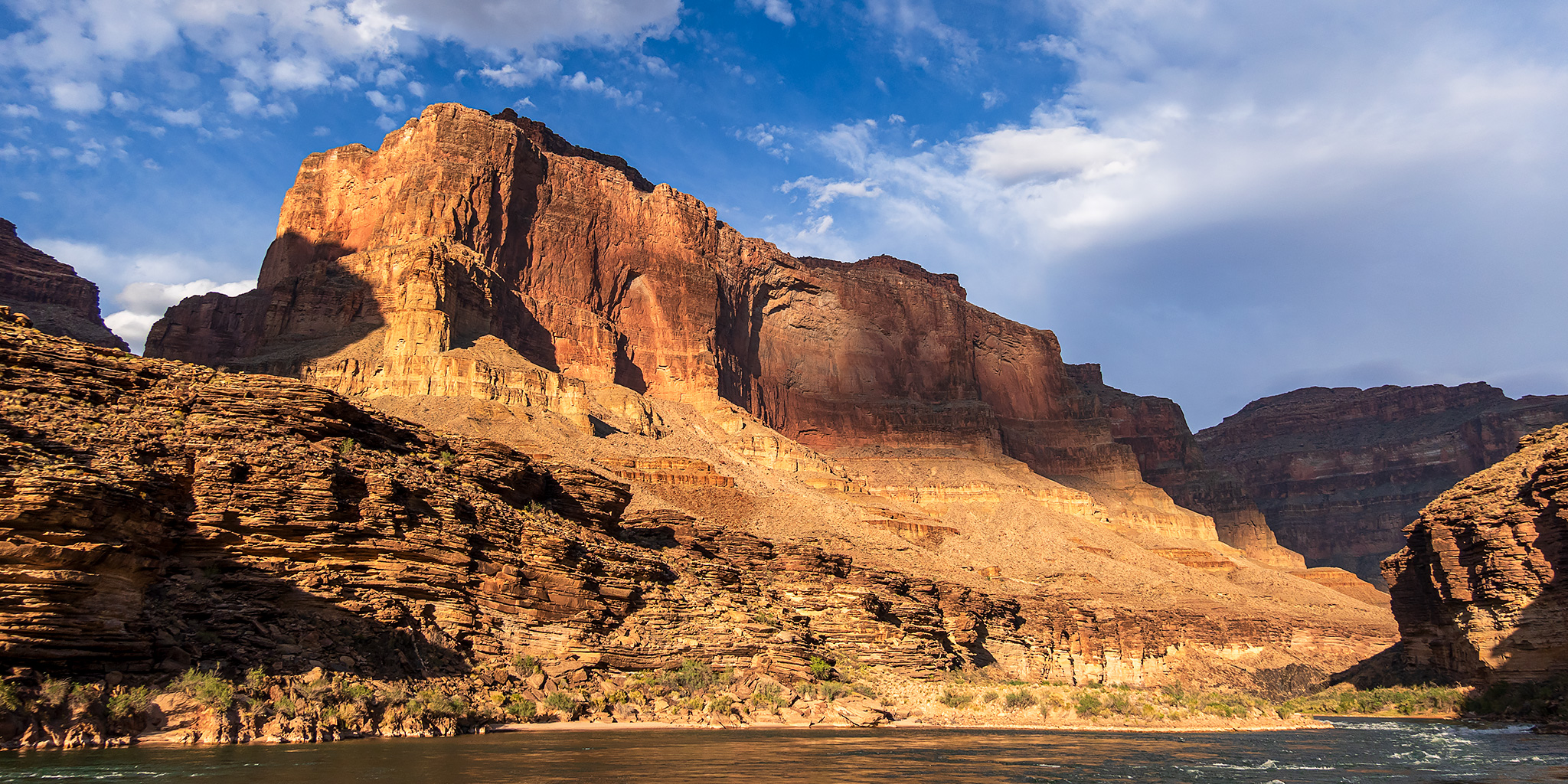
After the rest of the group made it down the trail and all the gear was loaded onto the rafts we started down the Colorado River through the Upper Granite Gorge.

Right away we went through Horn Creek Rapid, which was already bigger than any of the rapids we had experienced on the first half of the trip last year. What a way to start the trip!

The water was emerald green and smooth between the rapids.

Amazing views from deep within the Granite Gorge.

We only floated a few miles this afternoon so we could stop to camp and hike at Trinity Creek, so it was a short day on the river.

Before dinner we hiked though the narrows of Trinity Creek.


Trinity Creek Pools

This dryfall was the end of the hike and where we turned around.

After returning to camp from our hike we ate dinner and were in bed by 8:00pm. Both Diane and I were very tired from the long day, which would be a common occurrence during the remainder of the trip.
On Friday morning we were back on the river early after a hearty breakfast and enjoying the outstanding views. There were also a few big rapids along the way including Granite, Hermit and Crystal.


This bighorn sheep seemed interested in us.


After floating through the series of rapids known as The Gems we passed by the Ross Wheeler, which was built by Bert Loper and abandoned by Charlie Russell after several mishaps in 1915 during an expedition with the intent of making a motion picture of running the Grand Canyon by boat.

The characteristics of the canyon change this morning. The river is broader, the walls more sloping, and composed of black slates that stand on edge. These nearly vertical slates are washed out in places—that is, the softer beds are washed out between the harder, which are left standing. In this way curious little alcoves are formed, in which are quiet bays of water, but on a much smaller scale than the great bays and buttresses of Marble Canyon.
Major John Wesley Powell,
August 20, 1869
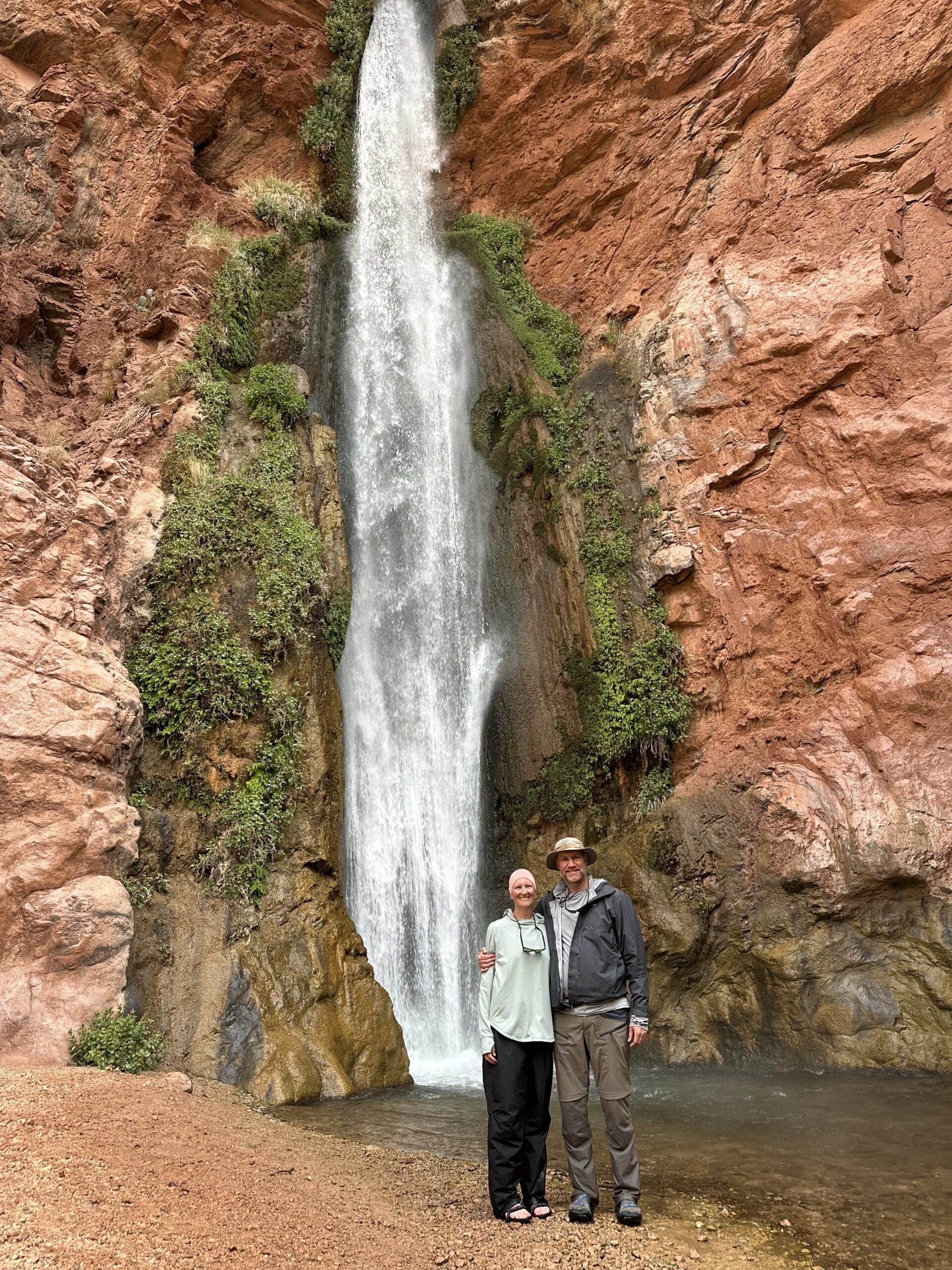
Right after passing the Bass Trail crossing we stopped to go on a short hike to a small waterfall just up Shinumo Creek.


Shinumo Creek Waterfall

Here’s a little video clip of the waterfall.
As we continued down the river we spotted these ewes and lambs that were climbing in the cliffs above us. They are very hard to see in this photo.

Here’s a short video clip of them climbing that Diane took.
Shortly before leaving the Granite Gorge we pulled the rafts into this little cove and ate lunch.

After lunch we stopped at Royal Arch Creek and climbed up into the Elves Chasm.

Elves Chasm Waterfall

Here’s a short video clip of the waterfall in Elves Chasm.
Elves Chasm

We continued on through Stephen Aisle and then stopped at Blacktail Canyon to go on one more short hike.

Blacktail Canyon Narrows

This little pool and pourover was our turnaround point.

Diane in Blacktail Canyon

This was a great place to see the Great Unconformity up close where the Tapeats Sandstone sits directly on the Vishnu Schist and approximately 1.2 billion years of the Earth’s history is missing at the contact.

A few of our guides brought along guitars and put on a little concert before we left the canyon.

After leaving Blacktail Canyon we crossed the river and set up camp just on the other side.

The light was looking nice on the walls of De Vaca Terrace this afternoon.

De Vaca Terrace

Our rafts tied up at Below Blacktail Camp.

We started Saturday morning with a nice float through Conquistador Aisle.

Light & Shadow


It wasn’t long until we got through Fossil Rapid and entered the Middle Granite Gorge.


Then, after making it through Bedrock and Deubendorff Rapids we stopped early for the day at the mouth of Stone Creek so we could camp here and go on a longer hike. Although there was already a Private Trip laying over at this site, they had no problems sharing the large campsite with our group.
We spent the remainder of the day hiking up Stone Creek.


Diane taking a break in the shade since much of this hike was in the warm sun.

Stone Creek Alcove


Although there were many small waterfalls along the way, this one caught my attention and was framed up nicely between two large boulders.


Three Small Falls

The canyon narrowed up near the end of our hike.

This waterfall at the end of the hike was difficult to get a photo of, so here’s a short video clip.
Stone Creek Narrows

Diane along Stone Creek during our hike back down.

Here’s one last look up Stone Creek Canyon as we made our way back down to camp for dinner.

It had been another long and tiring day and Diane fell asleep at camp before it even got dark out.

Our way to-day is again through marble walls. Now and then we pass for a short distance through patches of granite, like hills thrust up into the limestone. At one of these places we have to make another portage, and, taking advantage of the delay, I go up a little stream to the north, wading it all the way, sometimes having to plunge in to my neck, in other places being compelled to swim across little basins that have been excavated at the foot of the falls. Along its course are many cascades and springs, gushing out from the rocks on either side. Sometimes a cottonwood tree grows over the water. I come to one beautiful fall, of more than 150 feet, and climb around it to the right on the broken rocks. Still going up, the canyon is found to narrow very much, being but 15 or 20 feet wide; yet the walls rise on either side many hundreds of feet, perhaps thousands; I can hardly tell.
Major John Wesley Powell,
August 23, 1869
We only floated about three miles down the river on Sunday morning so we could spend the rest of the day hiking up Tapeats Creek to Thunder Spring.

Looking back to Tapeats Rapid as the trail climbed steeply.

After the steep climb the trail leveled out for a bit and traversed the ledges above Tapeats Gorge.

After a few ups and downs along the way, the trail turned and followed steeply up alongside Thunder River, which is one of the world’s shortest rivers.

Soon I had my first view of Thunder Spring, where the water gushes right out of the canyon wall.

Thunder River Trail

Thunder Spring is a very impressive sight!

Thunder River Falls

Here are two short video clips of the impressive spring and waterfall.
One more look at Thunder Spring emerging from the canyon wall before we started hiking back down.

The view from the Thunder River Trail wasn’t too bad, either.

Upper Tapeats Creek

Following Tapeats Creek back down the canyon.

Tapeats Creek Canyon

There were some nice views of the walls of the Tapeats Terrace as we made our way back to the mouth of the canyon.


This evening and night ended up being the windiest of the trip. There was so much sand blowing around camp that we ended up being served and eating dinner on the rafts to help keep sand out of the food, which is something none of our guides had ever done before! Lucky, I was so tired from another long day that I was able to sleep through the windy night pretty well.
We woke up to some great light on Fishtail Mesa early on Monday morning.

The rafts cut their motors and we listened to some river music as we floated through the Granite Narrows, the narrowest section of the canyon at only 76 feet wide.

Leaving the Narrows

A view of Tahuta Terrace as we stopped at Deer Creek for a short walk.

Just after dinner we pass a stream on the right, which leaps into’ the Colorado by a direct fall of more than 100 feet, forming a beautiful cascade. There is a bed of very hard rock above, 30 or 40 feet in thickness, and there are much softer beds below. The hard beds above project many yards beyond the softer, which are washed out, forming a deep cave behind the fall, and the stream pours through a narrow crevice above into a deep pool below. Around on the rocks in the cavelike chamber are set beautiful ferns, with delicate fronds and enameled stalks. The frondlets have their points turned down .to form spore cases. It has very much the appearance of the maidenhair fern, but is much larger. This delicate foliage covers the rocks all about the fountain, and gives the chamber great beauty. But we have little time to spend in admiration; so on we go.
Major John Wesley Powell,
August 23, 1869
We went on a short walk to see the impressive Deer Creek Falls.

Here’s a little video clip of Deer Creek Falls.
One of the guides took this photo of Diane and me below the falls.
After leaving the waterfall behind we had a lot of miles to make up today for our short days on the water previously. There were nice clouds and spotlighting on the canyon walls to keep be busy taking photos along the way.

It was nice to see the mouth of Kanab Creek Canyon as we passed by since I have spent much time hiking further up in the canyon.


Soon we passed by the mouth of Hundred and Fifty Mile Canyon, which is where I went on my very first hike into the Grand Canyon about fifteen years ago.

Just past Upset Rapid we got a quick view of this rusty pie tin on a rock which was placed there in memory of Shorty Burton, who was a Hatch River Expeditions guide that perished in the rapid in 1967.


Our next stop of the day was at Havasu Canyon, where we hiked up the canyon a short distance and ate lunch.

I took a few photos of the bright blue water of Havasu Creek as we hiked upstream, but it was overcast out the entire time and they are not that good compared to the photos I took during our backpacking trip into Havasu Canyon in 2019. Still, it was nice to finally see the mouth of the canyon since I was unable to hike down here on that trip.


The canyon is wider to-day. The walls rise to a vertical height of nearly 3,000 feet. In many places the river runs under a cliff in great curves, forming amphitheaters half-dome shaped.
Though the river is rapid, we meet with no serious obstructions and run 20 miles. How anxious we are to make up our reckoning every time we stop, now that our diet is confined to plenty of coffee, a very little spoiled flour, and very few dried apples! It has come to be a race for a dinner. Still, we make such fine progress that all hands are in good cheer, but not a moment of daylight is lost.
Major John Wesley Powell,
August 24, 1869
After leaving Havasu Canyon we spent the rest of the day motoring through the Muav Gorge.

It rained on us a little and was a bit chilly out…

…but eventually the sun came back out and lit up the magnificent canyon walls!

This herd of Bighorn Rams were too busy eating to care about us floating by.

Dark Clouds & Canyon Light

We stopped at the campsite at the mouth of Fern Glen Canyon for the night and then went for a short hike up the canyon before dinner.

Fern Glen Canyon Narrows

We had to climb up past this jumble of boulders.

The ferns of Fern Glen Canyon.

We had to backtrack a little bit and climb around this obstruction on the left side of the canyon.

This wet but not flowing waterfall was our turnaround point.

Leaving the Fern Glen Canyon narrows.

Most of Tuesday was spent motoring through the canyon to make up miles from our shorter days on the river earlier in the trip.

Passing by the mouth of Mohawk Canyon.

Thankfully it was another day filled with nice clouds and canyon light.

Coming up on Cove Canyon.

I was pretty excited when we reached the cliffs below the Toroweap Overlook.

Although I have seen Vulcan’s Anvil from high above before, it is much more impressive when you are right next to it. It is a 50-foot tall volcanic plug that serves as a warning to river runners that Lava Falls Rapid is just downstream.

Here’s one last look back to the Toroweap Overlook, which was where I got my very first view of the Grand Canyon back in 2011.

We make 12 miles this morning, when we come to monuments of lava standing in the river,—low rocks mostly, but some of them shafts more than a hundred feet high. Going on down three or four miles, we find them increasing in number. Great quantities of cooled lava and many cinder cones are seen on either side; and then we come to an abrupt cataract. Just over the fall on the right wall a cinder cone, or extinct volcano, with a well-defined crater, stands on the very brink of the canyon.
Major John Wesley Powell,
August 25, 1869
Lava Falls Rapid was a lot of fun in a large motor rig, but it sure looked like it could be tricky to run in smaller rafts…

After officially becoming part of the River Rat Club we continued on down the canyon.

It wasn’t long until we reached the ancient lava flows of Whitmore Canyon. It feels like just yesterday my Jeep was parked up on top of that dark black lava shelf when it was over 100 degrees out!


Floating past the mouth of Parashant Canyon.

Toward the end of our day we passed through Granite Park.

Ewe & Lamb


Our last stop of the day was at the geothermal heated spring known as Pumpkin Spring, which has the most poisonous water in the Grand Canyon. Soaking in the pool or drinking the water are not recommended.


Here’s one final view from Mile 214 before we stopped to spend our final night just across from Three Springs Canyon.

This morning the river takes a more southerly direction. The dip of the rocks is to the north and we are running rapidly into lower formations. Unless our course changes we shall very soon run again into the granite. This gives some anxiety. Now and then the river turns to the west and excites hopes that are soon destroyed by another turn to the south. About nine o’clock we come to the dreaded rock. It is with no little misgiving that we see the river enter these black, hard walls. At its very entrance we have to make a portage; then let down with lines past some ugly rocks. We run a mile or two farther, and then the rapids below can be seen.
Major John Wesley Powell,
August 27, 1869
Wednesday was another short day on the river, but we had to get an early start so we could get unloaded at Diamond Creek for our bus rides back to Peach Springs, Flagstaff and then to the South Rim to pick up our vehicle.

Diamond Peak was our signal that the take-out was just ahead.

We entered the very beginning of the Lower Granite Gorge this morning, which I am hoping to see much more of next year!

>> The Grand Canyon: Pipe Creek to Diamond Creek Photo Gallery
Wow, thanks for the posts Randy. It sure takes a lot of work but your reports are top notch.
Thanks Carter, it does take a lot of work for some of these Trip Reports, which is why it took so long to finally get this one up. Hopefully I can catch up on the rest this month!
Totally agree with Carter’s post; a lot of work and it is very much appreciated by your subscribers. Just beautiful!
Thank you Thomas!
Thank you Randy and Diane for letting us tag along on this magnificent journey…amazing!! Tom McC, McQueeney, Texas
Thank you for following along, Tom!
This was a great trip report – you got some great light down there in the canyon. I also really liked how you wove in Powell’s diary. Very nice touch.
Thanks Dan!