Utah’s Biggest Whitewater in Canyonlands National Park | Average CFS: 31,500
Friday – Sunday, May 31 – June 2, 2024
On starting, we come at once to difficult rapids and falls, that in many places are more abrupt than in any of the canyons through which we have passed, and we decide to name this Cataract Canyon.
Our way after dinner is through a gorge, grand beyond description. The walls are nearly vertical, the river broad and swift, but free from rocks and falls. From the edge of the water to the brink of the cliffs it is 1,600 to 1,800 feet. At this great depth the river rolls in solemn majesty. The cliffs are reflected from the more quiet river, and we seem to be in the depths of the earth, and yet we can look down into waters that reflect a bottomless abyss.
Major John Wesley Powell,
July 23, 1869
As many of you already know, I’ve spent a considerable amount of time exploring, hiking, backpacking, Jeeping and floating the rivers within Canyonlands National Park over the years. However, Cataract Canyon has been the one section of the Colorado River in Canyonlands that has eluded me over that time. Since there’s a pretty good chance I might never have the opportunity to navigate the large rapids of Cataract Canyon on a private river trip, I figured this would probably be a good place to try out a commercial river trip for the first time and see how it goes. So late last year I booked a 3-day motorized trip with Mild To Wild Rafting and then my friend Jackson did the same for his family so we could go on the trip together. Since we would be in a large raft with an experienced guide on this trip instead of in our little inflatable kayaks, we tried to time the trip to coincide with the highest water of the year that typically happens during spring runoff in late May and early June, and I think we ended up doing a pretty good job on the timing.
I usually don’t do very well around groups of people, which made me a bit anxious about going on a commercial river trip and is the main reason I chose to start out with a shorter 3-day trip so I wouldn’t be committed for too long if things didn’t work out. Plus, since we’ve already floated through Meander Canyon on our own before, I wouldn’t mind motoring through that part of the canyon quickly at the beginning of the trip. If all worked out well on this trial run, it would be a good time to start thinking about maybe booking a commercial trip through the Grand Canyon in the next couple of years, since I highly doubt I’ll ever be paddling that on my own, either.
On Friday morning we met up early at the Mild To Wild office and were shuttled over to the Potash Boat Ramp where we boarded the 28-foot S-Rig for our journey into Cataract Canyon.

The first day our our trip was mostly spent motoring down the flat water of Meander Canyon.

We relaxed and enjoyed the beautiful canyon views along the way. It was much easier taking photos when I didn’t have to worry about paddling my own boat.


After floating about ten miles downstream we entered the Goose Neck. You might recognize the wall on river-left which is highlighted at sunrise from the popular view at Dead Horse Point high above.

I just love the reflections on the flat water of the Colorado River in Meander Canyon.

Once on the other side of the Goose Neck we officially entered Canyonlands National Park.

We stopped to go on a short hike to the rock art and ruins found at Big Bend and then had lunch across the river near the mouth of Lathrop Canyon.

River Faces


Surprisingly, I had missed these white faces the last time I was here, so I’m glad we stopped to revisit this site.

After lunch it was back to a relaxing float down the river. Naps were taken by some.

We passed below a couple of ruins I had missed during our previous float.

Guillotine Arch

When we reached The Loop we were dropped off on the shore and left behind so we could hike over the saddle and meet the boat on the other side.

Starting our hike up The Loop Trail.

Diane and I had camped on a very nice sandy beach during the last night of our float down Meander Canyon a few years ago, but that beach was currently submerged. Actually, all of our campsites from that trip were under water this time.

Here’s a view from the highpoint of our hike at the top of the saddle of The Loop.

There’s our ride, coming around The Loop to pick us up.

Jackson and Amy hiking down the other side of the saddle to catch our ride.

We passed by a dark boulder that contained a couple of interesting petroglyphs that were hard to see and photograph.

Soon we were back on the raft again and motoring through the last few miles of Meander Canyon to The Confluence.


It wasn’t long until we were approaching The Confluence. The Heart of Canyonlands.

Here’s a view looking up to the overlook of The Confluence that Jared and I had hiked to from the White Crack a few years back. Stillwater Canyon and the Green River comes in from the left. We hopped into the water to swim and cool off while we were here.

Looking back to the large promontory of stone that juts out toward The Confluence from the Maze District.

We stopped to register for our upcoming campsites in Cataract Canyon.

Our first night was spent at the large sandy Brown Betty Beach, which I had hiked to from the Doll House about six years ago.

It certainly wasn’t a bad place to spend the night.

While I was waiting for dinner, I hiked downstream to the second set of rapids in Cataract Canyon.


There was a touch of color in the sky at sunset this evening.


We sat around the campfire after dark for a while before heading off to bed.

We start this morning on the Colorado. The river is rough, and bad rapids in close succession are found.
Major John Wesley Powell,
July 21, 1869
Saturday was rapids day! After having a hearty breakfast and packing up camp it was time to run the rapids of Cataract Canyon- Utah’s Biggest Whitewater! We pushed off from camp around 10:00am and the temperature was warming up quickly, which was perfect since we would definitely be getting wet today. Since we were going to be getting splashed, I packed my main camera away into my dry bag until we reached camp, so I only took a few shots with my waterproof camera plus a couple short video clips.
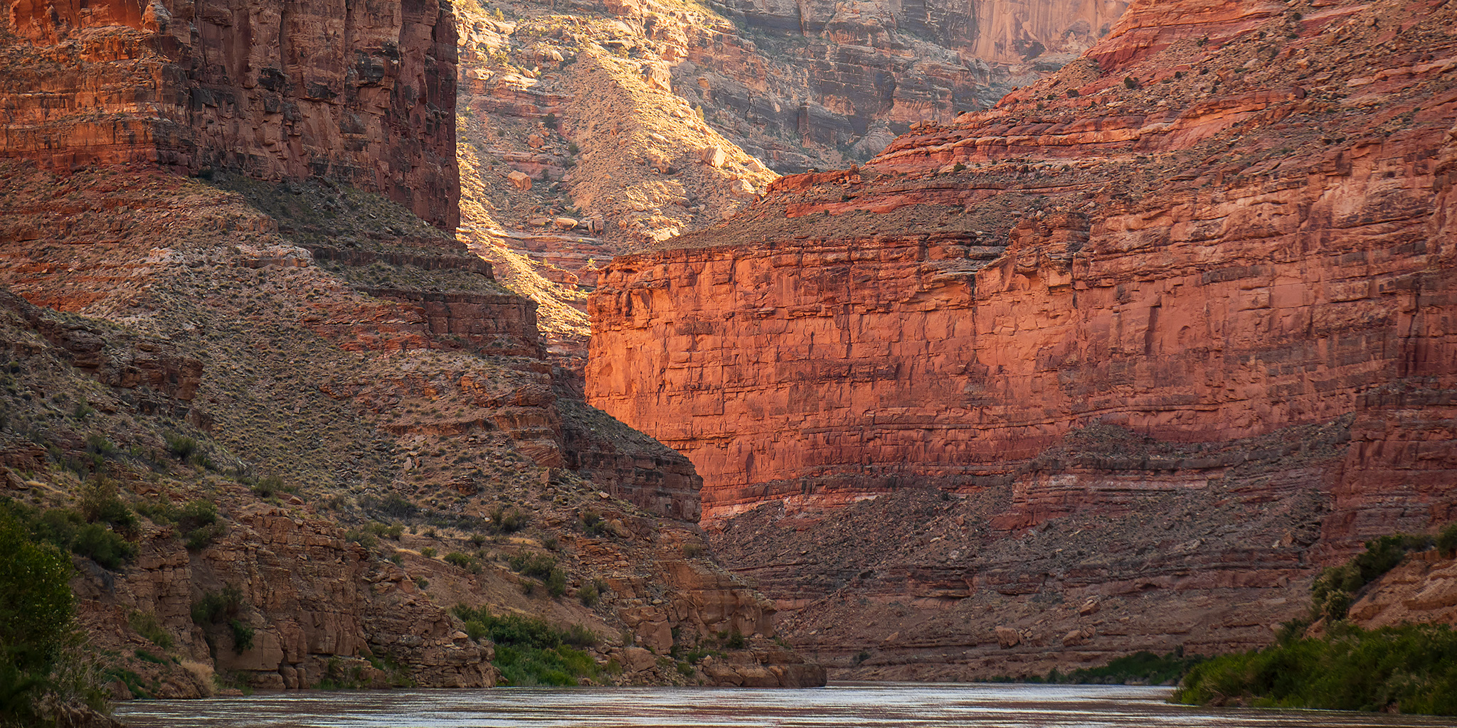
The tall walls in Cataract Canyon are very nice and much different from those found in Meander Canyon and Stillwater Canyon above. Here are a few quick photos taken between rapids.


This is a short video clip of one of the larger rapids we went through. It may not seem large in the video, but that’s because the 28-foot raft we were on was very large in comparison. These were most certainly the largest rapids I have ever been on!
We stopped to stretch our legs and scout Big Drop 2.

Big Drop 2 and 2.5
Big Drop 3
After we stopped for lunch on Ten Cent Beach, we then finished running the rest of the rapids in Cataract Canyon, which went by way too fast. Then we passed by the mouth of Gypsum Canyon and entered the Dominy Formation, which is the layer of lake sediment that was left behind when Lake Powell reached this far up into the canyon.

Floating past the mouth of Bowdie Canyon.


Our second camp was at a nice beach known as Best Western. It was a nice camp, but it was pretty hot out this afternoon when we arrived, so we hung out in the shade of the bimini on the raft until the sun finally disappeared below the cliffs.

There was a lovely view down Cataract Canyon from this campsite.

The S-Rig at Camp

I slept very well at another great campsite in Cataract Canyon.

After this the walls suddenly close in, so that the canyon is narrower than we have ever known it. The water fills it from wall to wall, giving us no landing-place at the foot of the cliff; the river is very swift and the canyon very tortuous, so that we can see but a few hundred yards ahead; the walls tower over us, often overhanging so as almost to shut out the light. I stand on deck, watching with intense anxiety, lest this may lead us into some danger; but we glide along, with no obstruction, no falls, no rocks, and in a mile and a half emerge from the narrow gorge into a more open and broken portion of the canyon. Now that it is past, it seems a very simple thing indeed to run through such a place, but the fear of what might be ahead made a deep impression on us.
Major John Wesley Powell,
July 28, 1869
On Sunday morning I woke up to this view of the morning light striking the rim of the canyon.

After another hearty breakfast and packing up camp, we were back on the water again motoring past the mouth of Cove Canyon as we continued down through the section of Cataract Canyon.


After a couple of miles our guide turned the large raft up the Mouth of Dark Canyon to see how far we could get.

He made is a surprisingly far distance up the canyon and was able to stop and turn around at a spot we could easily start hiking from.

We all went for a scenic hike up Dark Canyon.


Our turnaround point was at this waterfall and pool where we cliff-jumped and swam for a little while.

Dark Canyon Waterfall

All too soon, it was time to start heading back down the canyon to the raft. Some of us had a flight to catch…

At three o’clock we arrive at the foot of Cataract Canyon. Here a long canyon valley comes down from the east, and the river turns sharply to the west in a continuation of the line of the lateral valley. In the bend on the right vast numbers of crags and pinnacles and tower-shaped rocks are seen. We call it Mille Crag Bend.
And now we wheel into another canyon, on swift water unobstructed by rocks. This new canyon is very narrow and very straight, with walls vertical below and terraced above. Where we enter it the brink of the cliff is 1,300 feet above the water, but the rocks dip to the west, and as the course of the canyon is in that direction the walls are seen slowly to decrease in altitude. Floating down this narrow channel and looking out through the canyon crevice away in the distance, the river is seen to turn again to the left, and beyond this point, away many miles, a great mountain is seen. Still floating down, we see other mountains, now on the right, now on the left, until a great mountain range is unfolded to view. We name this Narrow Canyon, and it terminates at the bend of the river below.
Major John Wesley Powell,
July 28, 1869
Shortly after leaving Dark Canyon, entered the long curve of Mille Crag Bend and left Cataract Canyon behind as we entered Narrow Canyon.


When the river straightened out again, we could see the Henry Mountains in the distance, which signaled that the end of our river trip was getting close.


It wasn’t long until we were floating underneath the Highway 95 bridge near Hite.

As we go down to this point we discover the mouth of a stream which enters from the right. Into this our little boat is turned. The water is exceedingly muddy and has an unpleasant odor. One of the men in the boat following, seeing what we have done, shouts to ‘Dunn and asks whether it is a trout stream. Dunn replies, much disgusted, that it is “a dirty devil,” and by this name the river is to be known hereafter.
Major John Wesley Powell,
July 28, 1869

As soon as we passed the mouth of the Dirty Devil River, we stopped at the North Wash Boat Ramp and left the river behind. Although all the passengers got off the river here, the raft and two guides would continue another 50 miles downstream to Bullfrog where it would be loaded up onto a trailer the following day.
A Scenic Flight over Canyonlands National Park
After unloading our gear off the boat we got into a shuttle van that was waiting and headed over to the nearby Hite Airstrip to wait for our flight back to Moab. Although I was excited to see Canyonlands from above, I haven’t been on a plane in over a decade and have never been on a plane this small before, so I was a little nervous about the flight. After waiting for about an hour, the plane showed up and we headed over to board. Since the plane is loaded by weight, I was seated in the co-pilot seat and had to be extra careful not to bump the pedals or yoke (steering wheel) with my long legs and arms. Below are some of the photos I took from the plane above Canyonlands, but since this was my first time trying to take photos through the window of a plane, many of them have a weird color cast that I was unable to get rid of and they are not the best shots. As far as the flight goes, it was a bit of a bumpy ride in the heat of the afternoon, and even though I enjoyed seeing familiar places from above, I’m not quite sure if it’s something I would do again…
Waiting for our plane to arrive at the Hite Airstrip.

Here’s our ride back to Moab.

One last view from the Hite Airstrip before we boarded the plane.

Getting Ready to Fly

Here’s a short video clip during takeoff from the co-pilot seat.
After taking off we passed right over the North Wash Boat Ramp.

Looking up the mouth of North Wash.

Flying over the Mille Crag Bend.

The plane crossed over Cataract Canyon not far from where Jared and I had hiked to an overlook of the Big Drops near Teapot Canyon last November.

I had a great view over The Grabens and now want to plan another trip into the area.

There was a nice view over Chesler Park to the Abajo Mountains.

Flying over Cyclone Canyon where the Lower Red Lake Canyon Trail passes through.

Of course, we passed right over The Confluence. Now, not only have I viewed The Confluence from all three districts of Canyonlands National Park and floated right through it, I have also flown above it! This place truly is the Heart of Canyonlands!

Meander Canyon & Big Spring Canyon

There was a good view of The Loop as we flew by.

Looking straight down to the White Crack.

Grand View Point & Monument Basin

I had a good look down on the Murphy Trail as we passed right over.

Shafer Canyon & Dead Horse Point


Here’s one final view over Lone Mesa towards the La Sal Mountains before we landed at the Canyonlands Regional Airport.

After landing at the airport, a shuttle van took us back into Moab where we returned to our vehicles before 5:00pm. I grabbed dinner from Milt’s and then headed home after having a great three days on the Colorado River in Canyonlands National Park!
Even though I was initially worried about how I would be able to handle a trip like this, I have to admit that my first commercial river trip was a resounding success and I had an amazing time! Everyone on the trip, both the guides and fellow passengers, were nice and I think we all got along very well. In fact, I had such a great time that I may have already booked a commercial river trip next year in the Grand Canyon for Diane and myself…
Great post. Thx. I’m like you re: traveling in groups. Would you recommend the outfitter you used. Aerial photos of area are very cool.
Yes, I would highly recommend Mild To Wild based on this one trip. I’m thinking about booking another trip with them next year.