Tuesday – Saturday, August 19-23, 2025
Behold! The whole country beyond was smoking with the vapor from boiling springs, and burning gasses, issuing from small craters, each of which was emitting a sharp whistling sound.
Joseph L. Meek, 1829
Up until about a week ago Diane and I were planning to spend the latter part of this week backpacking in the Wind River Range in Wyoming, however some things came up that prevented us from going on a longer backpacking trip at this time, so we decided to change course and throw together a last minute trip to Yellowstone National Park instead. Neither of us had ever been to Yellowstone before and I’ve certainly always avoided the park because of the massive crowds it attracts, but I guess it was finally time to give the world’s first National Park a shot. So late last week I reserved a site at the Bridge Bay Campground for three nights and then came up with a rough itinerary that focused on visiting some of the areas around the lower Grand Loop Road, entering the park via Cody and the East Entrance and then leaving through the South Entrance into Jackson Hole. I had never even thought about planning a trip to Yellowstone before last week or been this far north in Wyoming before, and I had to consult a lot of maps and guidebooks to help me figure out the layout of the park rather quickly so our itinerary would make some sense.
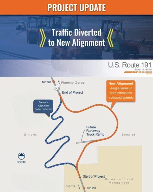 We left home after Diane got out of work on Tuesday evening and started our drive up towards Wyoming, but we stopped for the night at the Red Canyon Campground in the Flaming Gorge National Recreation Area to split up the drive. I guess the timing of our drive just north of Vernal was pretty good since the new realignment of US 191 had just opened and we got to drive the new section of the road, which was much nicer than the old switchbacks. We arrived at our reserved campsite just after dark, set up our tent and went right to bed. On Wednesday morning we were up shorty before sunrise and back on the road to continue the drive up to Cody.
Before getting back on the road we briefly watched the sunrise from the Red Canyon Overlook.

After stopping for lunch and fuel in Cody we followed the North Fork of the Shoshone River through the Absaroka Range and entered Yellowstone National Park through it’s East Entrance.

Once inside the park we made our first stop at the Lake Butte Overlook just before reaching the shore of Yellowstone Lake. It was mostly cloudy this afternoon and the wind was fierce!

After setting up our campsite at Bridge Bay we continued around the edge of Yellowstone Lake on our way to the West Thumb Geyser Basin. We stopped at this overlook of the Potts Hot Spring Basin along the way.

Danger!

Once we reached the West Thumb Geyser Basin we followed the boardwalk and checked out all the different thermal features that are found here.

The Black Pool is now blue.

Fishing Cone

Abyss Pool

On our way back to camp we stopped at Pumice Point. The strong winds were creating some decent sized waves on Yellowstone Lake this afternoon.

Pumice Point Shore

Before returning to camp we continued on to Fishing Bridge across the Yellowstone River.

Then we headed over to Pelican Valley to see if there was any wildlife around. There was not.

We watched the sunset from the shore of Yellowstone Lake just outside of Lake Village.

Yellowstone Lake Clouds

Absaroka Sunset

The clouds across the lake were very interesting this evening.

We returned to camp just after dark and went right to bed so we could get up early on Thursday morning to start our day at Old Faithful. After a pretty good night of sleep we were up at 5:00am on Thursday morning and quickly on the road to Old Faithful so we could wander around the Upper Geyser Basin just after sunrise and wait for an eruption.
The Land of Many Smokes

While we were waiting for Old Faithful to erupt we went for a short walk along the Firehole River.


Chinese Spring

Blue Star Spring

We returned to the viewing area at sunrise and waited for an eruption…

We waited longer than we would have liked for Old Faithful to erupt, but it ended up going off at exactly 8:00am.

This is a short video clip that Diane took at the beginning of the eruption.
Once the eruption was over we headed off to hike around the Upper Geyser Basin before the crowds of people really started to show up.

Color & Steam

Rising Steam


Doublet Pool

Ear Spring

Lion Geyser Complex

Firehole River


Grotto Geyser

Crossing the Firehole

Morning Glory Pool

Chain Lakes

We happened to walk by Castle Geyser as it was going off.

Here’s a short video clip of Castle Geyser.
After leaving Castle Geyser we followed the Continental Divide Trail back to Old Faithful and then headed off to check out other nearby geyser basins.

We passed this resting buffalo near the road.

After finding the other nearby parking areas and trailheads already full, we changed plans and hiked the old Fountain Freight Road and Ferry Creek Trail out to Imperial Geyser.

Twin Buttes

Imperial Geyser was a nice place to sit and rest in the shade for a little while since it was pretty warm out in the sun.

Here’s a short video clip of Imperial Geyser.
The colors found just below the geyser were pretty nice, too.

Instead of returning the way we had come, we made a loop and stopped by Fairy Falls along the way. This was also a nice cool place to sit and rest out of the sun for a bit.
 />
/>After our hike we went for a drive up along the Gibbon River and stopped to see Gibbon Falls.

Beryl Spring was right next to the road.

Then we returned to Firehole Canyon to see Firehole Falls.

Finally, later in the afternoon the parking areas started to clear out a little and we were able to check out the Midway Geyser Basin.

Excelsior Geyser Crater

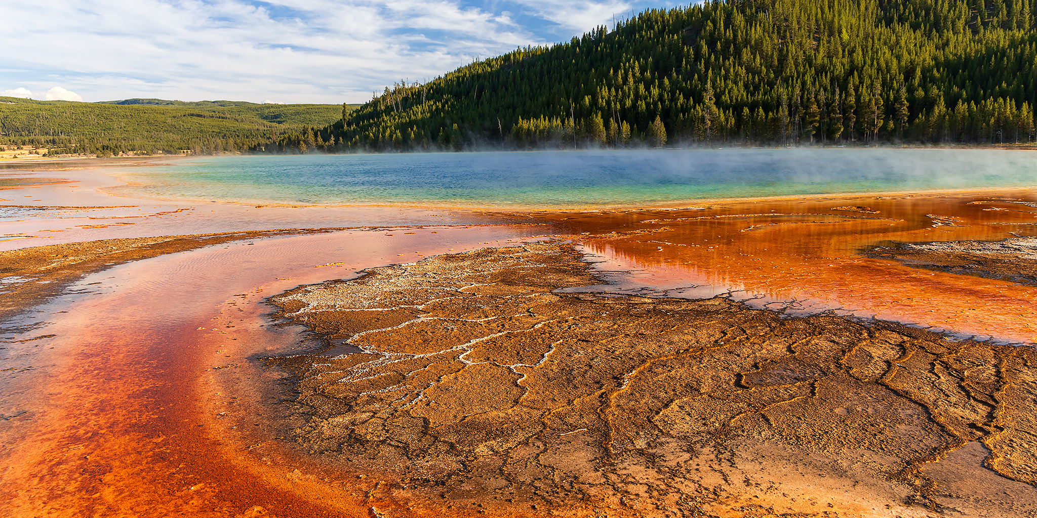
Grand Prismatic Spring

Opal Pool

Our last short hike of the day was along the Fountain Paint Pot Trail.
Clepsydra Geyser

Bobby Socks Trees

On our way back to camp we stopped at Craig Pass along the Continental Divide to check out Isa Lake. While it’s not really much of a lake, it’s very unique since it’s one of the few natural lakes in the world that drains into two different oceans, which is pretty cool!

Shortly before reaching the West Thumb Junction we spotted two wolves walking alongside the road, which would be the only wolves we would see on this trip. We returned to camp after dark again and went right to bed. Then on Friday morning we were up at 5:00am again and drove up to Dunraven Pass so we could start hiking the trail up to the Fire Lookout on Mount Washburn shortly before sunrise.
Starting our hike up the Mount Washburn Trail at dawn. Look closely and you might be able to spot the Fire Lookout in this shot.

There was a lot of smoke in the air this morning, apparently from wildfires in Idaho, which had moved into the area overnight and would stick around for the rest of our trip.

All the smoke helped make for a colorful sunrise, though.

First light on the Washburn Range.

Looking through the smoke across the Grand Canyon of the Yellowstone towards the Mirror Plateau.

The Mount Washburn Trail appears to follow the route of an old road.

Smoky View

Mount Washburn Ridge

On the summit of Mount Washburn.

The Mount Washburn Fire Lookout. I don’t think I’ve ever seen so many antennas on a Fire Lookout before…

Washburn, 1950

A view along the top of the ridge to the east.

Looking down over the trail we had just hiked up from the Fire Lookout.

After resting in the room at the base of the fire lookout for a little while, we shouldered our packs and started the hike back down to the pass.

Mount Washburn Trail View

Here’s one last look back at the Mount Washburn Fire Lookout from the trail on the ridge below.

After returning to our vehicle at Dunraven Pass we drove back down to the Grand Canyon of the Yellowstone and took in the view of the Lower Falls from Artist Point.

Grand Canyon of the Yellowstone

We also stopped for a view of the Upper Falls.

On our way to grab some lunch at Canyon Village we stopped at Inspiration Point, too.

After lunch we hiked the Mud Volcano Trail and saw the Dragon’s Mouth Spring, which was very loud and aptly named.

Here’s a short video clip of the Dragon’s Mouth Spring.
Mud Volcano Trail

We passed by this lone bison near the Yellowstone River as we headed back to camp to relax for a few hours.


Later in the afternoon we headed out to the Norris Geyser Basin and hiked both loop trails found there.

Porcelain Basin

Porcelain Terrace Overlook

Little Spouts

Green Dragon Steam

Cistern Spring

On our way back to camp shortly before sunset we spotted this elk in Cascade Meadows below Mount Washburn in the background.


We also saw another herd of buffalo in the Crater Hills of Hayden Valley.

Yellowstone River & Washburn Range

After our final night at the Bridge Bay Campground we slept in a little later on Saturday morning, took down our camp, and then left and headed south out of the park.
There was a little fog over Lewis Lake this morning as we drove by.

We made one final stop of check out the Lewis Falls.

After leaving Yellowstone National Park through the South Entrance and beginning our drive back home, we took a few hours to check out Grand Teton National Park for the first time even though it was still very smoky out today.
Thanks for bringing back memories of our own whirlwind visit to Yellowstone 13 years ago, where we tried to see as much as possible in 2.5 days. It was touristy and busy for sure in many spots, but visiting all the main geyser basins was very worthwhile nonetheless, and your photos capture that very well (as always!) Did you encounter any Geyser Gazers?
I had to look up what a Geyser Gazer is, but I’m pretty sure we did not see any.
We met several in September 2012, and their advice was very helpful in timing eruptions. Maybe there is an app for that now.