Raggeds Wilderness | Friday – Sunday, September 5-7, 2025
This weekend I returned to the Elk Mountains near Crested Butte so I could hike up to two passes in the Ruby Range that have been on my to-do list for far too long, both of which are found along the fringes of the Raggeds Wilderness above the Slate River Valley. Even though I didn’t have the best experience trying to find a campsite near Crested Butte back in July, there are still a lot of places in the area that I want to hike and explore so I decided to give it another shot after Labor Day weekend, which seemed to work out much better this time. As usual, I left from work on Friday afternoon, stopped for a quick dinner in Delta and then took the Kebler Pass Road over into Crested Butte and followed the Slate River up to the Paradise Divide where I found a campsite for the night. It started to rain on and off while I was driving over Kebler Pass which would keep up throughout the rest of the evening. Once I was settled in at camp I spent the remainder of the evening wandering around Paradise Divide when it wasn’t raining.
It was raining out as I drove up the road to the Paradise Divide.

Paradise Divide Camp

The Maroon Bells lit up when it stopped raining and the clouds opened up a bit.

A little light got through the clouds and lit up the Paradise Divide while I was hiking above.

A little evening light on Mount Baldy always looks nice.

Paradise Divide Tarn

Paradise Divide

Here’s one final view of the Maroon Bells at sunset just before I got into my sleeping bag and went to bed early.

After a pretty good night of sleep I was up early on Saturday morning and excited to hike a trail that has been on my to-do list for way too long! I drove just down the hill to the trailhead and started hiking up the Yule Pass Trail at dawn. This old mining track clings to the steep sides of Cinnamon Mountain and Treasury Mountain high above the Slate River Gorge and offers outstanding views the entire way with very little elevation gain.
Since this was an old road I was expecting the trail to be easy the entire way, and it was for much of the route…

…but there were a few sections where the old road had washed away completely and a narrow trail clung to the side of the steep and loose slope with a huge dropoff below.

As it got a little lighter out I could see that the sky was filled with heavy smoke this morning, which really muted the sunrise.

Down the valley I could see the Red Lady (Mount Emmons).

Then the distinctive peak of Crested Butte came into view.

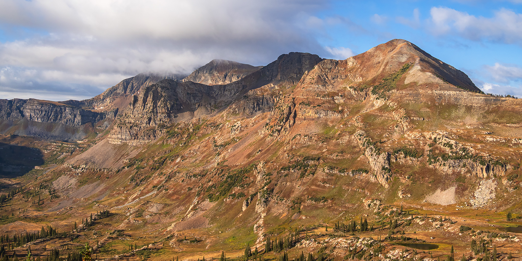
The first light of the day strikes the top of Purple Mountain on the other side of the gorge.

Smoky Morning Mountains

Following the old mining track up to Yule Pass.

Once around the final bend I had my first view through Yule Pass just as it was bathed in early morning sunlight.

Yule Pass

Just on the other side of the pass I entered the Raggeds Wilderness.
 />
/>There was a good view of the ridge on the south side of the Yule Creek Valley.

Unfortunately, it was pretty smoky on this side of the pass, too.

After dropping down the other side of the pass for a little ways, I left the main trail and started climbing up above the valley so I could visit the Yule Lakes.

I followed a beaten trail below the crest of Treasure Mountain.

Once I reached a little divide along the shoulder of the mountain the first and largest Yule Lake came into view.

Yule Lake

I walked to the other end of the lake on my way to the next little divide.

From the top of that divide I had a nice view over the next Yule Lake.

I passed another smaller lake on the way back.

After resting for a short while near the first lake I started the hiking out the way I had come.

Shortly after leaving the Yule Lakes I spotted a covey of four Ptarmigans.

Then I came across four more that were right on the trail.

As I followed the route back to the main trail it seemed like the smoke was starting to clear out a little bit and nicer clouds were forming above.

The little pass to the right of the peak is the route to the Yule Lakes.

The Yule Creek Valley was looking much nicer on the way back with less smoke and nice clouds.


Looking up to a little point below Treasury Mountain as I made my way back to Yule Pass.

Here’s one last look down Yule Creek before I crossed back over Yule Pass to the Slate River drainage.

The upper Slate River far below.

Following the Yule Pass Trail back down to the Paradise Divide.

Here’s one final look back to Yule Pass.

Purple Mountain

I passed by this small tarn near the trailhead just before returning to my vehicle.

After finishing the hike I drove down into Paradise Basin and over Schofield Pass as I completed a loop back into Crested Butte.

Elko Park

Before starting to search for another campsite for the night, I decided to go for a little scenic drive over Jacks Cabin Pass to the Spring Creek Reservoir and then loop around through Taylor Park and follow the Taylor River back to my starting point. It was a nice little drive through on and off rain this afternoon.
Spring Creek Reservoir & Italian Mountain

Here’s a rainy view over Trail Creek to the Continental Divide in the Sawatch Range as I followed the road into Taylor Park.

After grabbing dinner and gas in Gunnison, I returned to the Slate River Valley and found a designated campsite up in Poverty Gulch. Shortly after taking this photo of camp it began to rain and would continue lightly raining until sunset.

On Sunday morning I was awake before sunrise again, ate a quick breakfast and then drove further into Poverty Gulch so I could start hiking up the trail to Daisy Pass at dawn.
As I entered Baxter Basin I spotted these nice little cascades just off the trail.

The first light of the day strikes the ridge just south of Daisy Pass.

I watched a beautiful sunrise as I followed the old mining track through Baxter Basin.

Light Beneath the Clouds

I had a good view of Daisy Pass from below.

Baxter Basin Morning

After leaving the old mining road I started following the single-track trail up to the pass.

Basin & Clouds

There were a few short and steep switchbacks up the final slope to the pass.

Daisy Pass

There was a nice view of the Ruby Range over Democrat Basin on the other side of the pass. This area was familiar to me from a backpacking trip along Oh-Be-Joyful Creek, and it was nice to see from this higher vantage point.

I descended down the other side of the pass a short distance into the Raggeds Wilderness.

Daisy Pass View

After enjoying the views from the pass for a little while it was time to start hiking back down.

While I was hiking up to Daisy Pass fog had started to fill the Slate River Valley and Poverty Gulch below, which was interesting to watch.

Descending the Daisy Pass Trail.

River of Fog

Trees & Fog

Cascade Mountain

The fog was receding as I hiked back down so I never found myself within it, but it was fun to watch from above.

Poverty Gulch Fog

Looking into upper Poverty Gulch as I neared the trailhead.

This was my first view of Mineral Point that was not obscured by clouds this morning.

As I drove back down Poverty Gulch with the fog mostly gone, I had a nice view of Cinnamon Mountain. If you look closely you can see the Yule Pass Trail cut into the side.

The last remnants of fog in the Slate River Valley as I drove back to Crested Butte.

Whetstone Mountain in the Clouds
