San Juan Triangle | Friday – Sunday, July 12-14, 2024
After spending Thursday on the Colorado River in Westwater Canyon, I returned to work on Friday and then headed out afterwards to spend the weekend hiking in the San Juan Mountains between Silverton and Ouray. After making my way over Red Mountain Pass on the Million Dollar Highway to Silverton, I followed Cement Creek up into Velocity Basin and went for an evening hike along the shore of the little lake in the basin before finding a nearby campsite and getting to bed not long after sunset. Although hot, dry air has dominated the region for the past couple of weeks, afternoon storms were predicted to make a return this weekend, so I would have to make sure my hikes were planned accordingly by getting early starts.
Velocity Basin to Tower Mountain
It was a mostly overcast Friday evening in Velocity Basin.

Even though I was up above 11,000 feet, it was still very warm out and the snow found around the lake was melting very quickly.

Some warm sunlight did finally make an appearance after I headed down the basin a little way to find a campsite.

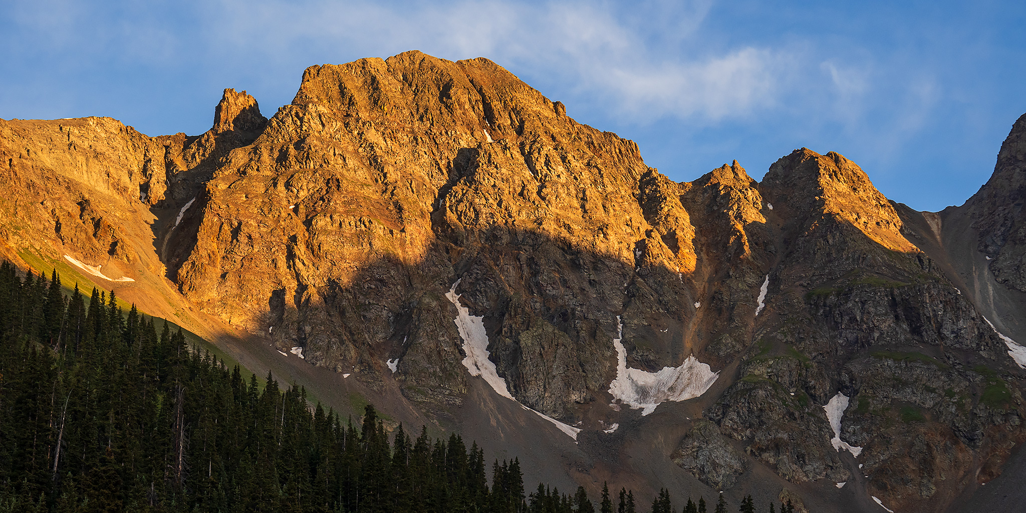
East Storm at Sunset


Last Light on East Storm

I was up early on Saturday morning and hiking up through Velocity Basin at dawn.

Watching the light and colors change as the sun came up.

First Light on Storm Peak


There was a nice view of the Red Mountains looking behind me as I climbed out of the basin.

East Storm Tower

Once I reached the top of the ridge I started heading towards Tower Mountain.

There was a nice view down into the South Fork of the Animas River from the ridge.

I joined the Boulder Gulch Trail for a short distance and then left the trail when I reached the saddle leading to Tower Mountain.

Following the rocky ridge…

A different view down to the South Fork of the Animas River.

The tower on the top of Tower Mountain soon came into view.

Looking back down the ridge I had just hiked up as I neared the top.

A view from the summit of Tower Mountain.

There was a nice view down to Hematite Lake in Hematite Basin.

Macomber Peak

Following the ridges on my way back down to Velocity Basin.


Descent into Velocity Basin

There were a couple nice patches of wildflowers in Velocity Basin.

After returning to my Jeep at the trailhead, I drove back down to Silverton and had an early lunch at Handlebars while I figured out what I was going to do for the rest of the day.
Richmond Basin: Richmond Trail to Richmond Pass
I was planning to hike into Richmond Basin near Ouray on Sunday morning and knew that I’d need to head that direction at some point this evening, but I still had plenty of time to get there, so before driving back over Red Mountain Pass I headed up towards Ophir Pass and started hiking along an unnamed trail towards an unnamed basin up above the Middle Fork of Mineral Creek. The storm clouds were building quickly, so I knew I’d probably be turning around and returning to my Jeep soon enough…
Trail to the Clouds

There were great views from along this unnamed trail, which I think probably would have eventually joined up with the trail to Columbine Lake.


Once I started hearing rumbles of thunder I turned around and headed back to my Jeep, and could see that the storm was above Paradise Basin and moving towards me.

I returned to the highway and made my way over to Ouray where I followed the Camp Bird Road and Imogene Pass Road up to Richmond Basin to look for a place to spend the night.
Richmond Falls

This deer in Richmond Basin didn’t seem to be bothered by my presence.

I ended up finding a campsite near Upper Camp Bird and walked through the old mining ruins later in the evening.

After a good night of sleep I got up early, drove to the Richmond Trailhead and started hiking at dawn.

Gilpin Peak at Sunrise

When I reached Richmond Pass I started following the ridge towards Hayden Mountain.

Full Moon Gulch

There was a hazy view across the valley to Red Mountain No. 2

I followed the ridge towards Hayden Mountain for a little ways, but it got too loose and steep for me, so I turned around and headed back to the pass.

Looking down into Richmond Basin from the ridge.

Another view down into Full Moon Gulch.

A hazy view along Hayden Mountain to the peaks of the Uncompahgre Wilderness.

Returning to Richmond Pass.

I hiked the other direction from the pass for a little ways to where I had a good view of T8.

Potosi Peak

There was a very nice view of Yankee Boy Basin and Mount Sneffels as I headed back down through Richmond Basin and then started my drive home.
