Press "Enter" to skip to content

Tag: trail guide

Grand Basin Traverse: The Basins of Mineral Creek

Black Bear Pass to Columbine Lake
Saturday, August 17, 2019

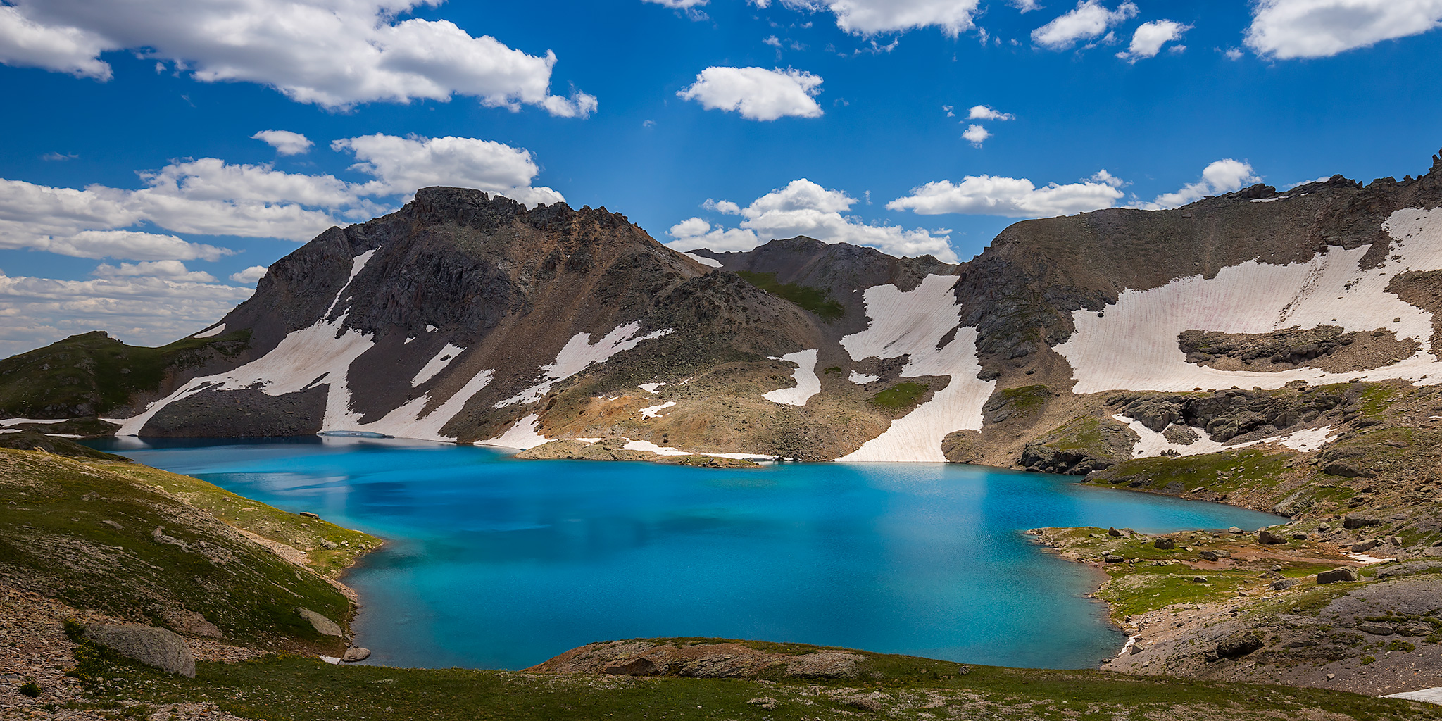
This weekend I decided to skip the peak bagging for a minute and just wanted to go on a nice hike in the high country through the upper basins of Mineral Creek near Silverton. I have wanted to hike to the turquoise blue waters of Columbine Lake for a long time but I didn’t really want to follow the steep trail that everyone else does, so I decided that I would drive up to Black Bear Pass and then hike over to the lake by passing through a couple different high alpine basins and maybe stop at a couple of passes along the way. Now after hiking this route I’ve got to say that it was pretty amazing! One of the nice things about this hike is that it was all above treeline and pretty much stayed between about 12,600 feet and 13,000 feet. There were a lot of ups and downs along the way, but it didn’t feel like I was climbing a steep mountain and the route offered spectacular views in all directions right from the beginning. This Grand Basin Traverse takes you through Mineral Basin, Porphyry Basin, Silver Cloud Basin and Mill Creek Basin on your way to Columbine Lake. Along the way you have the option of climbing up to two different passes for views into Mud Lake Basin and Bridal Veil Basin, plus you will also pass by Porphyry Lake, Bullion King Lake and a number of other small tarns along the way. This is definitely the way to hike to Columbine Lake!

8 Comments

The White River: Floating through the Uinta Basin

Bonanza Bridge to the Enron Ramp | Fantasy Canyon & Goblin City
Friday – Sunday, June 28-30, 2019

For the last weekend of National Rivers Month I definitely wanted to keep the streak going and get out on the river one last time before I started heading up into the mountains. I wanted to go somewhere new that wasn’t going to be crowded and that didn’t require a permit, so after looking at my options I decided to give the White River in Utah a try. There’s not too much information out there about this stretch of river, but from what I could find it looked like this would be a nice relaxing desert trip that doesn’t see too many people. The White River is born from snowmelt in mountain headwaters of the Flat Tops in western Colorado near where we hiked Sleepy Cat Peak early last summer, and then it flows west through Meeker and Rangely before entering Utah. From the state line it continues winding its way through the gas fields of the Uinta Basin along the northern edge of the East Tavaputs Plateau and joins the Green River in the Uintah and Ouray Indian Reservation. Our journey this weekend would begin at the Bonanza Bridge and end at the Enron Boat Ramp, which is about 35 miles of the river.

4 Comments

Colorado National Monument Traverse

The Face of the Monument | West to East
Saturday, April 12, 2014

Years ago I had the idea of hiking across the face of the Colorado National Monument from one entrance to the other but never seemed to get around to planning the route and following through on the hike because I was usually heading elsewhere for my weekends. A few weeks ago I told Diane about this idea and she was interested in joining me, so I finally got determined to follow through and started planning the route. Much of the route follows existing trails that I have hiked many times in the past, but there were a few segments that I needed to check out and find a few connecting off-trail routes between them. Over the past few weeks I have gone out a few times after work and scouted these segments to come up with the complete route.

3 Comments