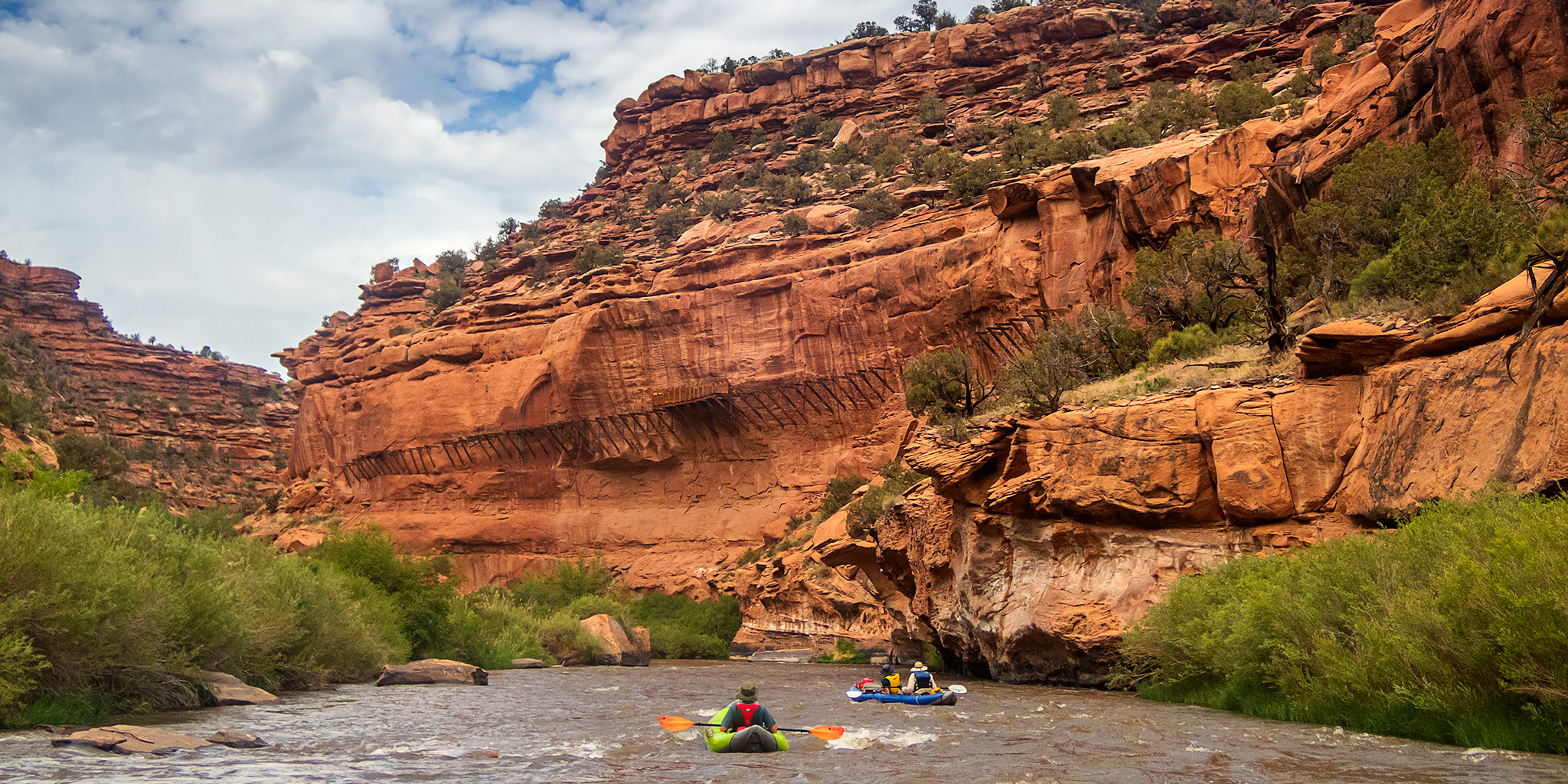
Press "Enter" to skip to content

Tag: red canyon

The Black Canyon of the Gunnison

Saturday, October 17, 2015

It’s been a few years since I had been to many of the main overlooks along the South Rim in the Black Canyon of the Gunnison National Park and I thought it was time to finally get back for another visit. Diane and I left home early enough on Saturday morning so that we were able to make it to the Cedar Point overlook about a half hour before the sun came up. I spent that time photographing The Painted Wall and the deep canyon below us until shortly after the sunrise. Once the sun was up we drove the rest of the way to the end of the road and hiked out to Warner Point since I had never been out there before. Clouds started rolling in from the west as we hiked back to the trailhead as a storm front moved into the area that was supposed to bring us some rain for the next couple of days. After our hike, we drove back out of the park and stopped at a couple of the other viewpoints along the way. Before leaving we drove down the East Portal Road to the Crystal Dam on the Gunnison River and were pleasantly surprised to find a couple nice patches of fall colors along the way. It’s always nice to spend a few hours along the rim of The Black Canyon.

2 Comments

Red Canyon & Wolverine Canyon

Southern Utah Wanderings 2015
Sunday, October 4, 2015

After sleeping in until the sun came up on Sunday morning we had a little breakfast and then decided to hike the Red Canyon Trail since the trailhead was located right in the campground. We weren’t sure how long the trail was, but we knew it couldn’t be too long since we could see where the canyon ended. It turned out to be a pretty easy hike that followed an old road then dropped into the wash that emerged from the mouth of Red Canyon. The trail eventually ended in a large amphitheater caved out of the Waterpocket Fold. When we returned to the trailhead we had hiked a bit over six miles according to my GPS. It was a nice morning hike to get warmed up for the day.

Leave a Comment

Monument Rain

Wednesday, July 8, 2015

On a whim, I decided to drive through the Colorado National Monument this evening to try and catch a nice sunset. The last few days we’ve had quite a few thunderstorms move through the Grand Valley and I was hoping that tonight’s storms might create some nice conditions.

Leave a Comment

Ute Trail

Sunday, February 8, 2015

After spending yesterday in Utah I decided to try hiking some new trails closer to home today. While I have been to the Black Canyon of the Gunnison National Park a number of times, I realized that I have completely neglected the Gunnison Gorge National Conservation Area just downstream. That sounded like a nice place to hike today, especially since I have been talking to my friend Jackson about running that stretch of the Gunnison River in the future. My original plan for the day was to start out by hiking down the Chukar Trail. This is a short one mile trail that descends 560 feet to the main boat put-in to run this stretch of the river. If you plan to run this section by boat, you either need to carry your gear down this trail or you can hire a company to have it packed down by mule.

Leave a Comment

Toms Canyon to the Little Dolores River

Saturday, December 6, 2014

In a recent conversation with a Facebook friend, he mentioned to me that there might be some rock art located along the Little Dolores River between two parcels of private property. After doing some research on the property boundaries and finding that access would probably be possible by hiking down Toms Canyon, I mapped a possible route on Google Earth that avoided all private property and stayed on BLM land to the area. The only concern I had left was finding an access point down into Toms Canyon from the rim. I had found a spot on Google Earth that looked good, but would not know for sure until I was there and checked it out for myself. On Saturday morning I decided to head up and give this hike a shot. After stopping at the Visitor Center in the Colorado National Monument to pick up a calendar that features one of my photos, I continued up through Glade Park to the Little Dolores Road and took it almost to it’s end at the private property. I turned off on a side road that lead to a campsite and started hiking from there. First, I had to climb to a short pass on a faint trail that gave me a nice view down into Toms Canyon. The faint trail I followed up to the pass pretty much ended there and I had to bushwhack through the steep and rocky wash on the way down into Toms Canyon. There was one rocky ledge that I thought was going to stop me and prevent me from going further, but after a little searching I managed to find a way down. It turns out that the route I had planned in Google Earth worked out perfectly. Once I was down in Toms Canyon the hiking was much easier and I followed some well-used cow trails.

Leave a Comment