Headwaters of the Whiterocks River | Friday – Sunday, August 9-11, 2024
After last week’s backpacking trip to the Red Castle Lakes in the High Uintas Wilderness I didn’t have any plans on returning to the Uinta Mountains anytime soon. However, after keeping an eye on the weather forecast around Colorado for the upcoming weekend, I couldn’t find a mountain range within a couple hundred miles of home that didn’t show stormy weather all day and night. It was going to be a wet and stormy weekend in the mountains of Colorado! I was originally hoping to spend the weekend hiking along the Continental Divide in the San Juan Mountains, but on Friday afternoon I made a last-minute decision to head up to the eastern end of the Uinta Mountains with hopes that I would be able to get some hiking in since the weather forecast for this area looked like the best around with only the typical afternoon storms. So for the second time in as many weeks I left from work and drove over Douglas Pass on my way to the Uinta Mountains. After a quick stop for fuel in Vernal I headed out across the Uinta Basin and then followed the Whiterocks River up to it’s headwaters at Chepeta Lake.
As soon as I arrived at Chepeta Lake a thunderstorm blew into the area and it started to rain.

After waiting out the first storm, it seemed like conditions were starting to clear up just in time for sunset.

I was just about to go for a short walk when the sky filled with clouds again and another thunderstorm overtook the area which chased me back into my Jeep.

There would be no sunset this evening as the sky stayed cloudy until after dark.

I headed back down the road to a nice campsite I had seen on the way up and got to bed early.
Since the stormy weather had cleared up overnight, I was up well before sunrise on Saturday morning and started hiking at dawn. My main destination this morning was to hike up to the Eccentric Benchmark (Chepeta Peak), which is the highest point in both Daggett County and Uintah County.
I followed the trail past Moccasin Lake where there was a touch of fog hovering above the surface of the water.

After crossing the Papoose Lake dam, I climbed a steep boulder-strewn slope and had a nice view over Moccasin Lake as the clouds started to change color.

Looking out across Papoose Lake as the cirque above Walk-Up Lake catches the first light of the day in the distance.

Morning light in the Uinta Mountains.

There seemed to be quite a bit of smoke in the air this morning as I looked back to Chepeta Lake.

After the steep bouldery climb above Moccasin Lake, it was an easy walk up the relatively gentle slope to the expansive summit of Chepeta Peak.

Eccentric Bench Mark

Interestingly, a couple hundred feet away from the Eccentric Benchmark is the Chepeta Benchmark, so I walked over to that one, too.

Chepeta 1958

Next I headed north to the edge of the mountain and started following the ridge towards Daggett Peak.

Another view of Chepeta Lake and the headwaters of the Whiterocks River.

The Chepeta – Daggett Saddle

From the saddle a had a good view over to Daggett Lake.

Nearing the rocky, but still flat, summit of Daggett Peak.

I continued down the west side of Daggett Peak and followed the ridge as I made a loop over to Walk-Up Lake.

There was a good view over to Spirit Lake from the ridge.

Walking along the edge with Jessen Lake and Tamarack Lake in view.

I dropped down for a view of Walk-Up Lake but didn’t get too close as storm clouds were building quickly behind me.

A little dry tarn I passed by in the trees as I made my way down toward Wigwam Lake.

I passed by Wigwam Lake as I closed the loop.

Walking back across the dam at Papoose Lake.

It wasn’t long before I returned to the shore of Chepeta Lake near the trailhead.


I heard the first rumble of thunder as I was putting my backpack into the Jeep. I had finished the hike just in time!

With thunderstorms now in the area after my hike, I did a little scenic driving to get a feel for this part of the Uintas. I took a different road down out of the mountains to the Uinta River and then drove to the end of the road in Uinta Canyon before turning around and heading back out. I also went for a drive up Whiterocks Canyon before leaving the area and returning to Vernal for an early dinner.
Red Cloud Loop to Leidy Peak
After finishing my dinner in Vernal, I headed up Dry Fork on the Red Cloud Loop Scenic Backway back into the Uinta Mountains. I explored a couple of side roads off the main loop, including the rough track that leads to the Ashley Twin Lakes before I made my way to the Leidy Peak Trailhead where I found a nice campsite nearby to spend the night at.
Dry Fork Overlook

There was a pretty nice view from the campsite.


Shortly after arriving at camp another thunderstorm overtook the area and unleashed a barrage of graupel on me, along with plenty of lightning and thunder.

It wasn’t long before a spot of light broke free of the clouds and lit up the mountaintop in front of me which created a rainbow.

Rainbow in a Storm

It got very bright and vibrant for a few minutes.

Looking at the other end of the rainbow.

After the storm had passed the clouds lit up nicely for sunset.


After it got dark out I was able to see flashes of lighting in the distance for a while as I drifted off to sleep. I slept pretty well this night and was up shortly before sunrise on Sunday morning so I could get a quick hike up to the summit of Leidy Peak before heading home.
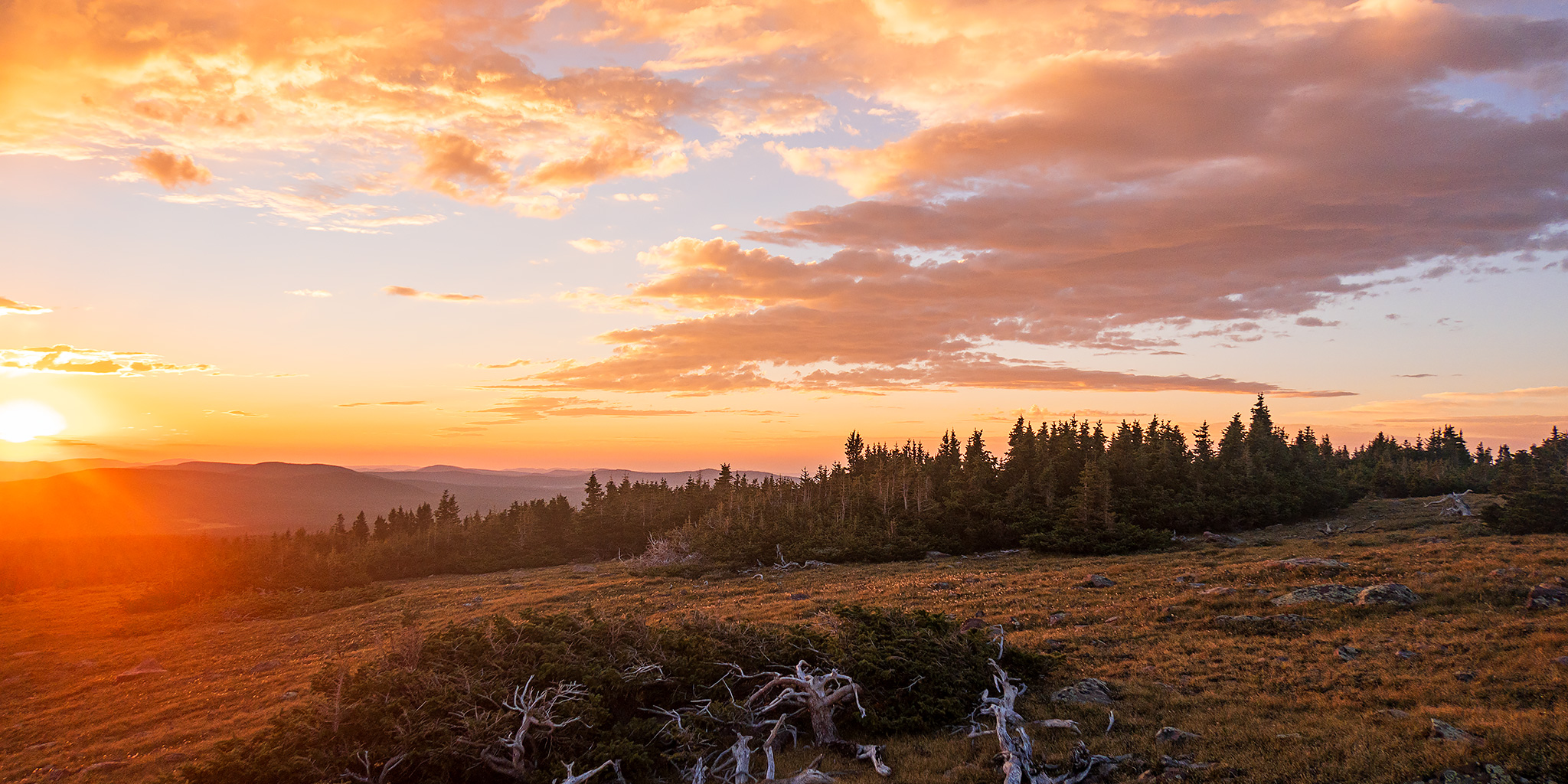
I watched the clouds change colors as I followed the Uinta Highline Trail towards Leidy Peak.

There must have still been some smoke in the air as the sun was bright red as it came up over the horizon this morning.

First light on the landscape.

It was a beautiful sunrise in the eastern Uintas!

Warm morning light on Leidy Peak. My route would follow the north ridge on the very right side of this photo.

A Distant Hazy View

There was a good view across the basin to Mount Untermann.


As I neared the summit of Leidy Peak I startled a herd of elk that were hanging out on top. They didn’t stick around for long…

View from the Top

Leidy Peak Summit

Leidy Bench Mark

After enjoying the views from the summit for a while, I returned to the trailhead the way I had come.

When I made it back to my Jeep, I finished driving the Red Cloud Loop back to the highway, returned to Vernal for gas and then headed back home. As I made my way over Douglas Pass, I noticed there was a lot of dried mud and dirt across the road that had not been there on Friday, so the area must have seen a lot of rain and some mudslides on Saturday!