El Malpais National Monument & El Morro National Monument
My 40th Birthday Foray into Arizona and New Mexico
Sunday, February 16, 2020
The last day of my 40th Birthday Foray into Arizona and New Mexico had finally arrived and although we technically had one more day left for the trip because of Presidents Day on Monday, we decided that we would rather drive home later this evening and have Monday off to rest and get ready to go back to work on Tuesday than stick around another day. After spending the night in Los Lunas we started driving west on historic Route 66 toward Grants so we could visit The Malpais (an extensive area of rough, barren lava flows) of New Mexico for the first time. We had started this week-long adventure along the old Route 66 at Petrified Forest National Park in Arizona the previous weekend, and now we would be ending it just down the road from there in New Mexico.
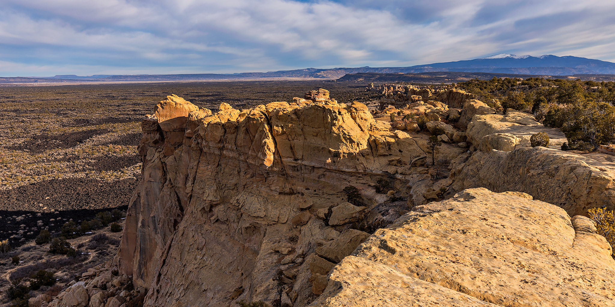
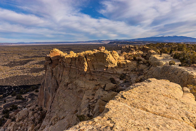
We started off the day by heading into El Malpais National Monument so we could make a quick visit to La Ventana Arch, which is the largest natural arch found in New Mexico. On our way to the arch we saw a turnoff for the Sandstone Bluffs Overlook and decided to check that out first.
I’m glad we stopped at the Sandstone Bluffs Overlook since it was a nice view early this morning with Taylor Mountain (11,301) on the horizon.
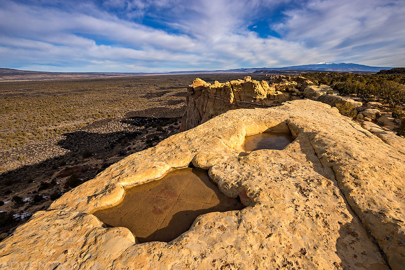
There were a few potholes in the sandstone filled with water and covered with a thin sheet of ice.

If you look below the sandstone bluffs you can see The Malpais (lava flow) below.
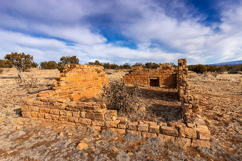
On our way back to the highway from the overlook we passed the old Garrett Homestead which was built sometime between 1935 and 1937. Most of the homesteading families of the El Malpais were victims of the Dust Bowl and Great Depression who traveled to this area to begin new lives in the American West.
After leaving the Sandstone Bluffs we continued down the road to La Ventana Arch which is located outside of the Monument in the El Malpais National Conservation Area.
Welcome to El Malpais National Conservation Area.

There was nice light on the cliffs of Cebollita Mesa as we hiked the short trail to La Ventana Arch.

La Ventana Natural Arch. New Mexico’s largest arch!

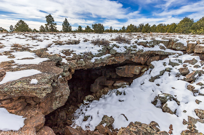
After returning to the trailhead we headed back into Grants so we could stop at the Visitor Center for El Malpais National Monument. We picked up a map and asked about the road conditions. I had hoped to visit the Big Tubes Area today, but because of the recent storm system that had moved through the area earlier in the week, the roads were going to be too muddy for Diane’s Edge. Instead, we decided to head over to the the El Calderon Area since it’s located right off the paved highway. As we drove to the trailhead we noticed that there was a lot of snow on the ground and the dirt roads we passed looked like they were a muddy mess, so I knew that we had made the right decision not to attempt driving any of the back roads in the area. Even the parking area and hiking trail at the El Calderon Area were very muddy when we arrived, so we decided not to hike any further than the closest lava tube today.
Looking down into the entrance of the lava tube located near Junction Cave.
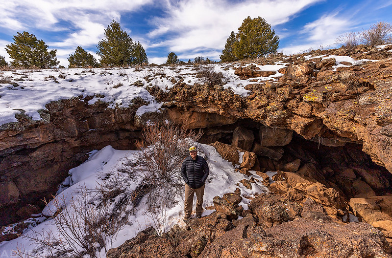
We climbed inside for a look around.

Then we rock-hopped through the tube to the opening on the other side.

Looking out the opening on the other side.

Diane coming out of the lava tube before we walked back to our vehicle and continued on.
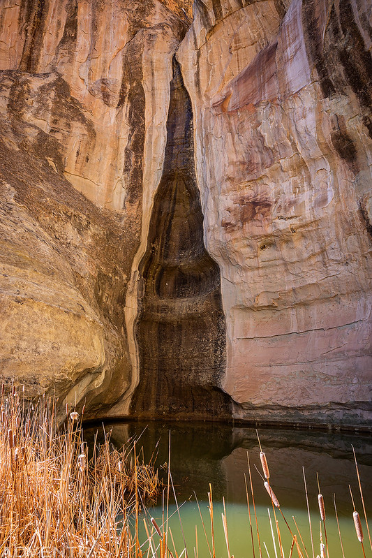
Although we only made a couple of brief stops in El Malpais National Monument this morning, I can tell you that it left us wanting to explore more. We have already discussed returning to this area during warmer weather for an extended trip of hiking and caving! After leaving the El Calderon Area we continued along the highway through Cibola National Forest and over the Continental Divide until we reached El Morro National Monument. A reliable waterhole hidden at the base of a sandstone bluff made El Morro a popular campsite for hundreds of years where Ancestral Puebloans, Spanish and American travelers carved over 2,000 signatures, dates, messages, and petroglyphs.
Welcome to El Morro National Monument.

This was our first good view of Inscription Rock as we drove into El Morro.

We started out by hiking the Inscription Rock Trail which follows along the base of the cliff where all the inscriptions are found.

We passed the reliable pool of water that attracted travelers to this location.
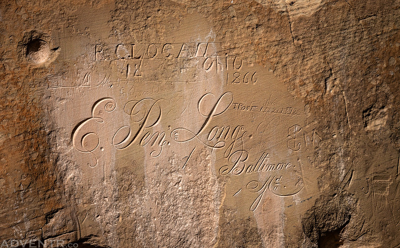
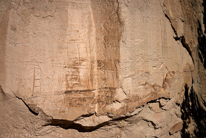
We saw many old inscriptions (the oldest ones I have ever seen) carved into the base of the sandstone cliff along the trail, but unfortunately we happened to be there during the absolute worst part of the day as many of them were obscured by shadows cast from nearby trees. I think it would be best to visit this spot later in the day or during an overcast day. I’ll share a couple of the oldest and more interesting inscriptions I saw below, even though the light was terrible on many of them.
E. Penn Long of Baltimore was a member of a U.S. Army expedition led by Lt. Edward F. Beale to find a wagon route from Fort Smith, Arkansas, to the Colorado River. The group, which first passed by El Morro in 1857, was testing the usefulness of camels in crossing the deserts of the Southwest. Though Beale wrote positively about the camels in his journals, the Army abandoned the experiment at the onset of the Civil War.
P. (Peachy) Breckinridge was the man in charge of the twenty-five camels used by Lieutenant Beale in 1857. After his work with Beale, Breckinridge returned to his home state of Virginia and fought in the Civil War. He was killed during a skirmish at Kennon’s Landing, Virginia in 1863.

Here is a panel of petroglyphs found among the inscriptions.
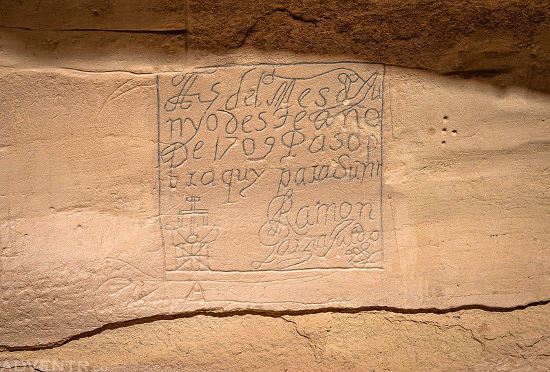
“On the 25th of the month of June, of this year of 1709, Ramon Garcia Jurado passed through here on the way to Zuni.”
“Here was the General Don Diego De Vargas, who conquered For our Holy Faith, and for the Royal Crown, all the New Mexico, at his expense, Year of 1692”

This is one of the oldest and most famous inscriptions at El Morro National Monument. Don Juan de Oñate was the first governor of New Mexico and left this inscription in 1605.
“Govenor Don Juan de Oñate passed through here, from the discovery of the Sea of the South on 16th of April, 1605”

Here’s a shot of just some of the many inscriptions carved into the very point of Inscription Rock.

After checking out the inscriptions we hiked the Mesa Top Trail to the ruins on top of the mesa.
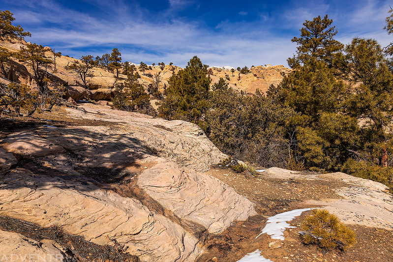
The ruins of the Atsinna Pueblo.

After hiking all of the trails that were currently open in El Morro it was time for us to start driving home. Originally, I was planning on completing the loop back home by driving up through Farmington and Durango and then over Red Mountain Pass, but after checking the weather I saw there was a snowstorm in the San Juan Mountains that I really didn’t want to drive through, so I thought it would probably be better for us to drive back across the Navajo Nation to Highway 191 and take that back home through Monticello and Moab.
Driving through Gallup and Window Rock gave us an opportunity to make a quick stop at Window Rock on our way home, too.

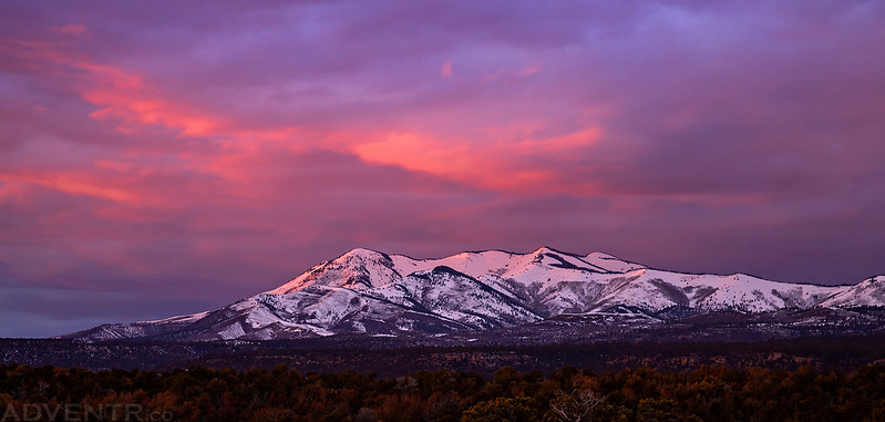
This was the last sunset of our trip near the Abajo Mountains taken from Highway 191 between Blanding and Monticello.
The remainder of the drive was uneventful and we made it home late in the evening and then got to rest all day on Monday before going back to work. All in all, we had a really great time on this trip and even with the cold front and winter storms that moved through the area in the middle of the week we were still able to do just about everything I had planned this week. Now it’s time to get back to my weekend adventures closer to home on the Colorado Plateau!
Love it!