Press "Enter" to skip to content

Tag: pronghorn

Devil’s Thumb & The Awesome ‘Dobie Badlands

Adobe Badlands Wilderness Study Area & Roubideau Creek
Friday & Saturday, May 7-8, 2021

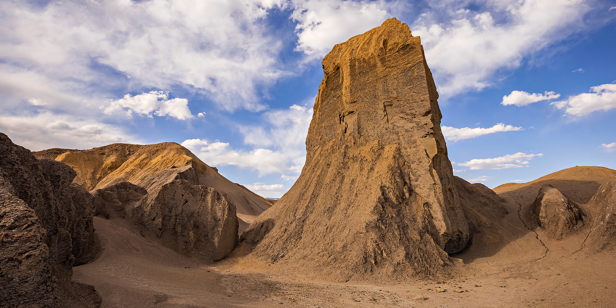
Next week Diane actually has a full week off from school between semesters and we are planning on spending that time in northern Arizona and New Mexico so she can get away from studying for a little bit. Since I still have a lot to do around the house to prepare for that trip I didn’t want to stray too far away from home this weekend, so I decided I would just head out for a quick and easy overnight trip to explore the Adobe Badlands and Roubideau Creek near Delta. I left straight from work on Friday, grabbed a quick dinner in Delta and then drove over to the edge of the Adobe Badlands Wilderness Study Area just north of town so I could hike up to the Devil’s Thumb this evening. I notice the Devil’s Thumb every time I drive through Delta and always think to myself that I should make the time to visit it, so this hike has been long overdue. It was about 90 degrees and very windy out when I started hiking, so it was a bit warm but at least the wind made it feel a little cooler and also kept any bugs away!

Leave a Comment

The White River: Floating through the Uinta Basin

Bonanza Bridge to the Enron Ramp | Fantasy Canyon & Goblin City
Friday – Sunday, June 28-30, 2019

For the last weekend of National Rivers Month I definitely wanted to keep the streak going and get out on the river one last time before I started heading up into the mountains. I wanted to go somewhere new that wasn’t going to be crowded and that didn’t require a permit, so after looking at my options I decided to give the White River in Utah a try. There’s not too much information out there about this stretch of river, but from what I could find it looked like this would be a nice relaxing desert trip that doesn’t see too many people. The White River is born from snowmelt in mountain headwaters of the Flat Tops in western Colorado near where we hiked Sleepy Cat Peak early last summer, and then it flows west through Meeker and Rangely before entering Utah. From the state line it continues winding its way through the gas fields of the Uinta Basin along the northern edge of the East Tavaputs Plateau and joins the Green River in the Uintah and Ouray Indian Reservation. Our journey this weekend would begin at the Bonanza Bridge and end at the Enron Boat Ramp, which is about 35 miles of the river.

4 Comments

Muddy Creek Country

The Grand Gorge of Muddy Creek & Skyline Rim
Friday – Sunday, May 11-13, 2018

This weekend I left after work on Friday and headed down into Muddy Creek Country at the southern end of the San Rafael Swell. I have wanted to hike into the Grand Gorge of Muddy Creek for many years now and decided it was finally time to go do it! As I was driving west into Utah there was a pretty strong headwind which killed my fuel mileage, but since the weather forecast was predicting strong winds all weekend, I was expecting it. I just hoped that the wind gusts wouldn’t interfere with my plans too much. It’s just the typical spring weather on the Colorado Plateau! I made a quick stop in Green River to fill up my tank and then continued up onto the Swell where I planned to spend the night near the old Hidden Splendor Mine.

8 Comments

Island in the Sky

Christmas Weekend in Moab | Saturday. December 24, 2016

On Saturday morning, Diane and I left home and headed down to Moab so we could spend Christmas Day in Arches National Park like we do every year. Since the holiday fell on a weekend this year, we decided to spend the entire weekend around Moab starting with a visit to the Island in the Sky District of Canyonlands National Park on Saturday. While Diane has been to The Maze and Needles Districts a bunch of times with me, she had actually never visited the Island in the Sky, which happens to be the most accessible of the three. We would spend the day visiting most of the overlooks and going on a few short hikes.

1 Comment

Rabbit Valley Exploring

Wednesday, August 31, 2016

I drove out to Rabbit Valley near the Utah state line after work this evening to spend a few hours exploring some of the area. I ended up driving a few backroads in the area I had not been on before and visiting a couple of overlooks and then I hiked down into Ruby Canyon from the rim on an old cattle trail. I also visited a few small petroglyphs and pictographs that were found in a shallow alcove that contained some lithic scatter nearby. It was a nice way to spend the evening and I didn’t see another person until I was back near I-70.

Leave a Comment