Saturday – Wednesday, April 5-9, 2025 | Low CFS: 9,500 – High CFS: 12,000
We are now ready to start on our way down the Great Unknown. We are three quarters of a mile in the depths of the earth, and the great river shrinks into insignificance as it dashes its angry waves against the walls and cliffs that rise to the world above; the waves are but puny ripples, and we but pigmies, running up and down the sands or lost among the boulders. We have an unknown distance yet to run, an unknown river to explore. What falls there are, we know not; what rocks beset the channel, we know not; what walls rise over the river, we know not. Ah, well! we may conjecture many things.
Major John Wesley Powell,
August 13, 1869
While rafting through the Grand Canyon has long been a dream of mine and an eventual necessity to complete my goal of floating all the sections of the Colorado River, Green River and their major tributaries across the Colorado Plateau, I figured that a private trip through the canyon is probably unlikely for me anytime soon and knew I would have to go on a commercial trip if I wanted to experience the canyon from the river. Last summer I went on my first commercial rafting trip through Cataract Canyon as a trial run to see how I would be able to handle a trip like this since it was shorter and closer to home. I ended up having a great time on that trip so I immediately booked a trip into the Grand Canyon for Diane and myself.
I definitely wanted to go on a hiking-focused trip when the temperatures at the bottom of the canyon were not too hot, and April sounded like the perfect time of the year to me, so I booked a Hiker’s Special Motor Trip with Arizona River Runners. We chose to go on the motor trip since we were limited on time off from work, plus Diane has had some bad experiences with rapids in the past and didn’t want to go on any raft smaller than a motorized rig. Also, because of our limited time off from work, we went with the five-day Upper Canyon trip from Lees Ferry to Pipe Creek Beach with a hike up to the South Rim on the Bright Angel Trail at the end, with hopes to complete the second portion of the trip through the canyon next year. I really think splitting up the trip up over two years will allow me to enjoy the canyon more anyways.
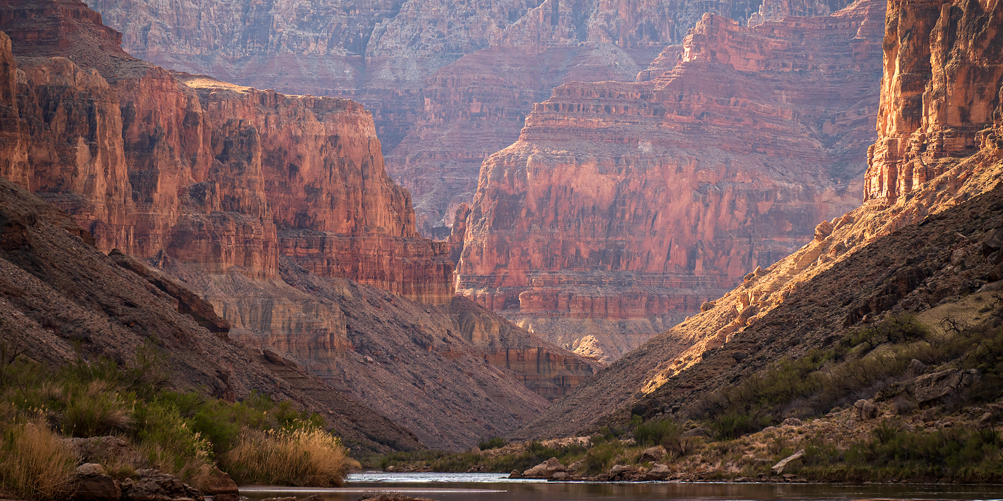
The Colorado River: Marble Canyon & Granite Gorge
After driving down to Flagstaff on Friday we met up with the rest of the group at the designated hotel early on Saturday morning and then took a shuttle bus over to Lees Ferry where we packed our gear into drybags, met with the guides for our initial orientation and then got on the large rafts to begin our journey down the Colorado River through Marble Canyon. A cold front had passed through the area on Friday which had left a fresh coat of snow on the peaks surrounding Flagstaff and had dropped the temperatures at the beginning of our trip a little lower than we would have liked.
It’s kind of funny, I had never been to Lees Ferry until last month, and now I’ve been here twice in the last two weeks!

With some feeling of anxiety we enter a new canyon this morning. We have learned to observe closely the texture of the rock. In softer strata we have a quiet river, in harder we find rapids and falls. Below us are the limestones and hard sandstones which we found in Cataract Canyon. This bodes toil and danger. Besides the texture of the rocks, there is another condition which affects the character of the channel, as we have found by experience. Where the strata are horizontal the river is often quiet, and, even though it may be very swift in places, no great obstacles are found. Where the rocks incline in the direction traveled, the river usually sweeps with great velocity, but still has few rapids and falls. But where the rocks dip up stream and the river cuts obliquely across the upturned formations, harder strata above and softer below, we have rapids and falls. Into hard rocks and into rocks dipping up stream we pass this morning and start on a long, rocky, mad rapid. On the left there is a vertical rock, and down by this cliff and around to the left we glide, tossed just enough by the waves to appreciate the rate at which we are traveling.
Major John Wesley Powell,
August 5, 1869
We quickly passed the mouth of Cathedral Wash as the walls of Marble Canyon quickly rose above us.

After making it a few miles downstream we passed beneath the Navajo Bridges that span the canyon.

There were no California Condors on the bridges as we passed underneath, but I had spotted one when we drove across on the bus earlier in the day.

After going through Badger Creek Rapids we stopped for lunch on a nice beach.

Below Jackass Beach

Tenmile Rock stands up tall in the middle of the river.

Soap Creek Rapids

Canyon walls, still higher and higher, as we go down through strata. There is a steep talus at the foot of the cliff, and in some places the upper parts of the walls are terraced.
Major John Wesley Powell,
August 6, 1869

It was still pretty chilly out as we went through House Rock Rapids, which ended up feeling like the biggest rapids we would go through on the entire trip as we hit the bigger holes on the left side.

Passing through the Boulder Narrows.

Look closely between the Redbud trees to see the two very young lambs on the boulders.

Since we spent most of the morning with the shuttle bus ride and orientation there were no stops for hiking on the first day, but we stopped to camp at Mile 19.4 Mile which would set us up for a hike into North Canyon the following morning.

S-Rigs & River Guides at Mile 19.4 Camp

Drying out our gear at camp after a cold and splashy day on the river.

The limestone of this canyon is often polished, and makes a beautiful marble. Sometimes the rocks are of many colors—white, gray, pink, and purple, with saffron tints. It is with very great labor that we make progress, meeting with many obstructions, running rapids, letting down our boats with lines from rock to rock, and sometimes carrying boats and cargoes around bad places.
Major John Wesley Powell,
August 8, 1869
After our coldest night of the trip temperatures would begin to warm up over the next few days.

Even though we were part of a much larger group than I am accustomed to being with, everyone was here for hiking and were ready and on the water before 8:00am so we could go on our first hike up North Canyon.

The early morning light was nice in North Canyon.


North Canyon Narrows

This pool in the canyon was our turnaround point on this hike.

After our morning hike we were back on the river in Marble Canyon as the day warmed up.

We made a short stop to explore this little cave just upstream from Tiger Wash.

Tiger Wash Cave Arch

Much of our Sunday was spent floating through the rapids of the Roaring Twenties and enjoying the views along the way.


We passed beneath this Great Blue Heron Nest.


Stanton’s Cave

Riding down a short distance, a beautiful view is presented. The river turns sharply to the east and seems inclosed by a wall set with a million brilliant gems. What can it mean? Every eye is engaged, every one wonders. On coming nearer we find fountains bursting from the rock high overhead, and the spray in the sunshine forms the gems which bedeck the wall. The rocks below the fountain are covered with mosses and ferns and many beautiful flowering plants. We name it Vasey’s Paradise, in honor of the botanist who traveled with us last year.
Major John Wesley Powell,
August 9, 1869
Unfortunately, Vasey’s Paradise was very dry as we passed by.

Redwall Monument

Soon we found ourselves approaching the massive Redwall Cavern.

The water sweeps rapidly in this elbow of river, and has cut its way under the rock, excavating a vast half-circular chamber, which, if utilized for a theater, would give sitting to 50,000 people. Objection might be raised against it, however, for at high water the floor is covered with a raging flood.
Major John Wesley Powell,
August 8, 1869

Of course, we stopped to spend a little time inside the Redwall Cavern.


Continuing on down Marble Canyon.

Although you cannot see it in this photo, there was a waterfall flowing behind the rock here that was pretty cool.

Bridge of Sighs

We passed by the Marble Canyon Dam Site where test holes were bored into the Redwall for a planned dam that thankfully was never built.

It was a lovely afternoon in Marble Canyon.

Arizona River Runners

And now the scenery is on a grand scale. The walls of the canyon, 2,500 feet high, are of marble, of many beautiful colors, often polished below by the waves, and sometimes far up the sides, where showers have washed the sands over the cliffs. At one place I have a walk for more than a mile on a marble pavement, all polished and fretted with strange devices and embossed in a thousand fantastic patterns. Through a cleft in the wall the sun shines on this pavement and it gleams in iridescent beauty.
Major John Wesley Powell,
August 9, 1869

Later this afternoon we stopped to camp at the mouth of Buck Farm Canyon and went for a hike up the canyon while dinner was being prepared. This was my favorite hike of the day.


Weeping Wall

Columbine

Lines & Light

We would see a lot of Western Redbud in bloom throughout our trip this week.

I loved the lines of the walls in this canyon.


Our hike ended when we reached this water-filled slot canyon.


Hiking back down Buck Farm Canyon.


Diane in Buck Farm Canyon.

We have cut through the sandstones and limestones met in the upper part of the canyon, and through one great bed of marble a thousand feet in thickness. In this, great numbers of caves are hollowed out, and carvings are seen which suggest architectural forms, though on a scale so grand that architectural terms belittle them. As this great bed forms a distinctive feature of the canyon, we call it Marble Canyon.
Major John Wesley Powell,
August 9, 1869
On Monday morning we quickly passed the Royal Arches and then followed the large bend in the canyon around Point Hansbrough.


We glimpsed the remains of an Anasazi Foot Bridge high above the river.

The morning light in the canyon was spectacular as we made our way to the mouth of Saddle Canyon, which would be our first hike of the day.

Here’s a shot of our large group hiking up into Saddle Canyon. It’s definitely a much different experience from the typical hikes I do alone or with a friend or two. I typically hung out at the back so I could take photos away from everyone else when I could.

After the initial steep climb the scenery in Saddle Canyon was very nice.


Diane Under the Redbud


The light and colors got even nicer as the canyon narrowed.


Saddle Canyon Slot


This hike ended at this small waterfall in a narrow slot canyon.


Hiking back out of Saddle Canyon.

Cardinal Monkeyflower

Our next hike was one I’ve been looking forward to for a long time. The views down the Colorado River from this trail were pretty amazing!

At the top of the trail we reached the popular Nankoweap Granaries.

Between the Walls

Nankoweap Granaries

Looking up to some smaller ruins in an alcove next to the more popular granaries.

Following the Nankoweap Granaries Trail back to the river.

After our hike up to the granaries we continued on down the river below the Desert Facade until we stopped to camp just below Malgosa Canyon.


Opposite Malgosa Evening


Opposite Malgosa Camp

On Tuesday morning we got another early start since we had a long day ahead of us, with many miles to cover and a few more hiking stops along the way.

It wasn’t long until Cape Solitude came into view.

At two o’clock we reach the mouth of the Colorado Chiquito. This stream enters through a canyon on a scale quite as grand as that of the Colorado itself. It is a very small river and exceedingly muddy and saline. I walk up the stream three or four miles this afternoon, crossing and recrossing where I can easily wade it. Then I climb several hundred feet at one place, and can see for several miles up the chasm through which the river runs.
Major John Wesley Powell,
August 10, 1869
After a couple miles on the river we stopped at the confluence with the Little Colorado River which was running bright blue this morning.

Little Colorado River


This Desert Spiny Lizard was hiding out in the shade to steer clear of our passing group.

We didn’t have much time to linger at the Little Colorado this morning and it was still too chilly out for a swim, but we hiked up the gorge far enough to see the Beamer Cabin across the river.


I just love seeing the different colors of two rivers coming together…

As we continued down the canyon we passed salt deposits leaching out of the Tapeats Sandstone.

Hopi Salt Mines

Chuar Butte

Canyon Layers

Motoring through the Furnace Flats.

We made a brief stop on the Unkar Delta where we saw plenty of potsherds and this metate and mano along the trail.

The Apollo Temple seen from the trail on the Unkar Delta.

Solomon Temple

While lunch was being prepared at the mouth of Seventyfive Mile Creek, the group went for a short walk up through the narrows which were very nice.


Leaving the narrows of Seventyfive Mile Creek in time for lunch.

After lunch we were back on the river to tackle the largest rapids of the trip (Hance & Sockdolager) as we entered the Granite Gorge.

At daybreak we walk down the bank of the river, on a little sandy beach, to take a view of a new feature in the canyon. Heretofore hard rocks have given us bad river; soft rocks, smooth water; and a series of rocks harder than any we have experienced sets in. The river enters the gneiss! We can see but a little way into the granite gorge, but it looks threatening.
Major John Wesley Powell,
August 14, 1869


Just before stopping at our final campsite of the trip we went on one more hike up Clear Creek.


Canyon Treefrog

I enjoyed hiking through the narrows and flowing creek of this canyon.


Our turnaround point on this hike was at the unusual Sideways Waterfall, and since it was warm out this afternoon most of us got underneath the falls to cool off.


Here I am almost slipping and falling as I tried to cool off under Sideways Falls.
Headed back down the lovely perennial stream.

It was just a short float from the mouth of Clear Creek to our final campsite at Zoroaster.

Zoroaster Camp

It was a lovely evening at a very nice campsite in the Granite Gorge.

Wednesday morning was our day to hike out of the canyon to the South Rim, but first we had a few more miles and rapids to go before we reached the trail at Pipe Creek Beach.

It wasn’t long until we were floating beneath the Kaibab Suspension Bridge (Black Bridge) at the bottom of the South Kaibab Trail.

We were lucky enough to catch a mule train crossing the bridge.

I liked the look of this rock as we dropped a few passengers off at Boat Beach so they could visit Phantom Ranch while they waited for the new guests currently hiking down the Bright Angel Trail to arrive.

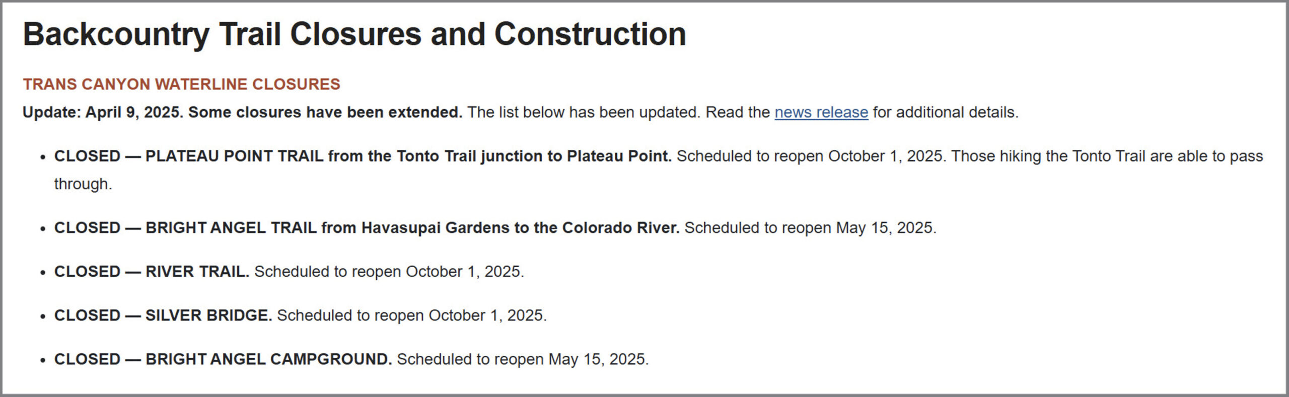
Soon we were back on the river and passing below the Silver Bridge, which is currently closed because of the Transcanyon Waterline Project.

The view as we were nearing the end of the river portion of our trip.

Granite Gorge Layers

River to Rim: Bright Angel Trail to the South Rim
Early in the afternoon we discover a stream entering from the north—a clear, beautiful creek, coming down through a gorgeous red canyon. We land and camp on a sand beach above its mouth, under a great, overspreading tree with willow-shaped leaves. The Colorado is never a clear stream, but for the past three or four days it has been raining much of the time, and the floods poured over the walls have brought down great quantities of mud, making it exceedingly turbid now. The little affluent which we have discovered here is a clear, beautiful creek, or river, as it would be termed in this western country, where streams are not abundant. We have named one stream, away above, in honor of the great chief of the “Bad Angels,” and as this is in beautiful contrast to that, we conclude to name it “Bright Angel.”
Major John Wesley Powell,
August 16, 1869
After reaching Pipe Creek Beach it was time to start hiking up to the South Rim on the Bright Angel Trail. Of course, this just so happened to be the warmest day of our trip so far and temperature at Phantom Ranch would reach the mid-90’s by the afternoon. It actually ended up being so warm today that there was unfortunately even a death further downstream in Lake Mead National Recreation Area from the record heat. It sure would have been nice to have the cooler temperatures that we had started out the trip with now!
The lower portion of the Bright Angel Trail was currently closed until mid-May, but commercial river trips were still allowed to do passenger exchanges through the closed trail, so we had the lower portion of the trail to ourselves this morning.
Starting our hike through the construction on the Bright Angel Trail.

The River Trail to Phantom Ranch was also closed.

Following Pipe Creek up the Bright Angel Trail in the morning shade.


Cheops Pyramid framed by the shadows of the canyon.


It wasn’t long until we reached the switchbacks and stairs of the Devils Corkscrew.

It got much warmer out once we were in direct sunlight.

Looking back to the Devils Corkscrew.

Bright Angel Trail


Following a ledge above Garden Creek as we neared Havasupai Garden.

Shortly before reaching Havasupai Garden there was a steep detour of the trail that jogged us over to the Tonto Trail for a little bit.

After a long rest at Havasupai Garden and topping off our water bottles, we continued up through the Redwall.

The Battleship

A view over to Grandeur Point as we neared the rim.

Here’s one last view from near the top of the trail looking back over the Grand Canyon.

Although Diane was moving slow near the top thanks to our heavier-than-normal packs, she made it to the rim and onto the shuttle bus with seven minutes to spare before it was scheduled to leave and bring us back to our hotel in Flagstaff.
I’m not going to lie, as you might be able to guess travelling and hiking in a group this large is not really my cup of tea, but overall we had a pretty good group of people on the trip and the guides and meals were great, so I still managed to have a nice time on the river and thoroughly enjoyed seeing the Grand Canyon from this vantage. We had such a nice time that we may have already booked the second part of the trip for next year…
>> The Grand Canyon: Lees Ferry to the Bright Angel Trail Photo Gallery