Press "Enter" to skip to content

ADVENTR.co Posts

Dry Fork of Coyote Gulch Slot Canyons

Southern Utah Wanderings 2010 | Day 2
Sunday, October 3, 2010

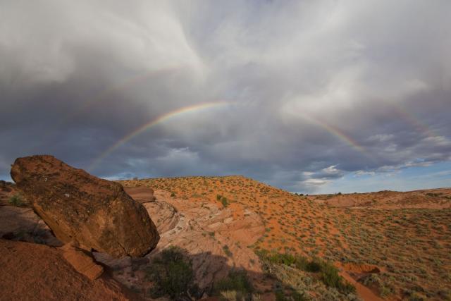
After getting some more sleep we still managed to get up for an early start and headed down into the Dry Fork of Coyote Gulch after some breakfast. Our destination this morning would be the Peek-A-Boo and Spooky slot canyons. There were some storm clouds north of us towards Escalante and some way at the southern end of the Straight Cliffs, but the area above this drainage was still clear. On our way down into the canyon those clouds provided us with a couple of rainbows to photograph.

Leave a Comment

Capitol Reef to Chimney Rock

Southern Utah Wanderings 2010 | Day 1
Saturday, October 2, 2010

On Saturday morning I left Grand Junction and headed into Utah. I made my way through Green River and Hanksville before reaching Capitol Reef. My destination was Escalante, but I would be getting off of the pavement for a little bit on the way. I took the Scenic Drive past Capitol Gorge where the pavement turned to dirt. With all the storms Southern Utah had seen this year, I wasn’t sure if the road was going to be washed out or not, but I got lucky and it wasn’t too bad. There were a few rough sections, but nothing a high clearance vehicle couldn’t handle.

Leave a Comment

Flat Tops Trail

Fall Colors 2010
Saturday, September 25, 2010

On Saturday morning Amanda and I headed to Meeker for our annual Fall Colors trip. This year we would be checking out the Flat Tops Trail Scenic Byway. This road is about 80 miles in length and connects the towns of Meeker and Yampa. Both ends are paved for a number of miles and the section in the middle is a well-maintained gravel road…..but we weren’t here for a challenge, we were here to check out the scenery. I wasn’t sure what to expect in terms of fall colors along this route, but luckily we were able to find some nice colors along the way.

Leave a Comment

Liberty Cap

Saturday, September 18, 2010

Yesterday morning Amanda and I headed to the Colorado National Monument to hike the full Liberty Cap Trail. I have hiked it from the bottom before, which is a shorter, but steeper hike. This time I wanted to start from Rim Rock Drive and hike across Monument Mesa to Liberty Cap, and then finish off the trail to the bottom. The full trail was about 7 miles in length and took us about 4 hours to complete. Here’s a couple of pictures I took along the way.

Leave a Comment