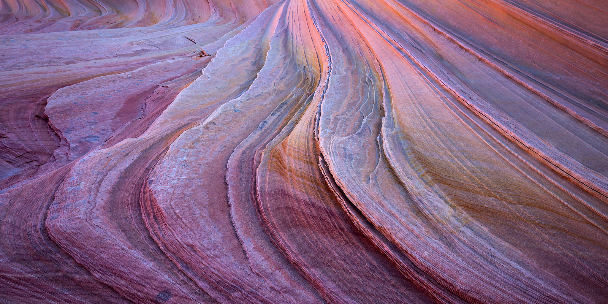
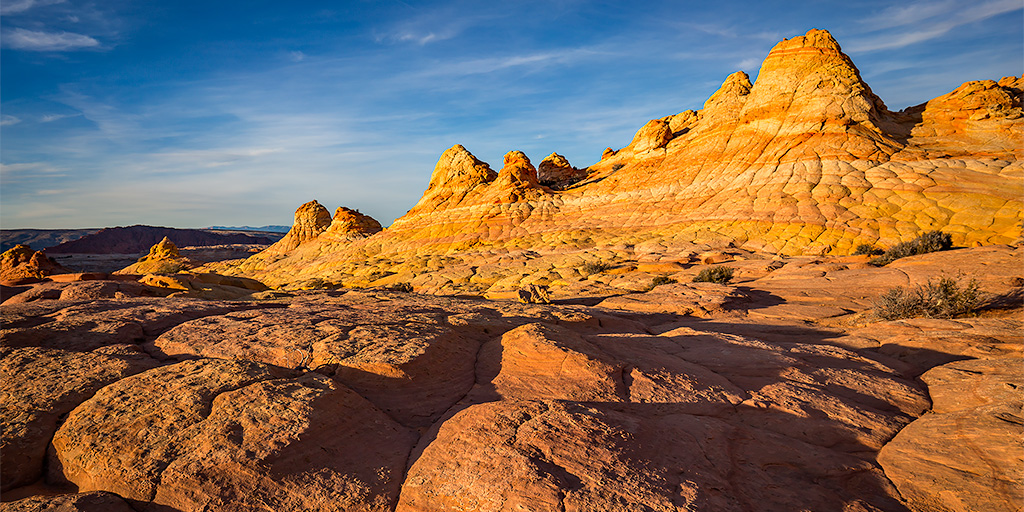
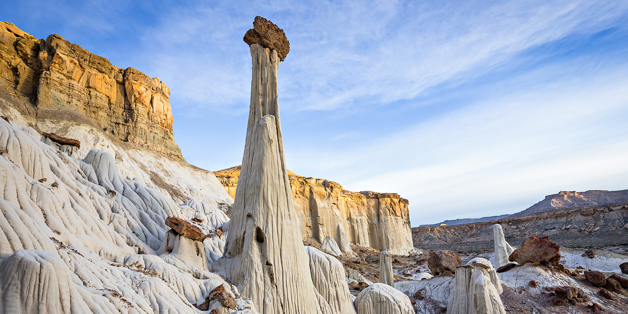
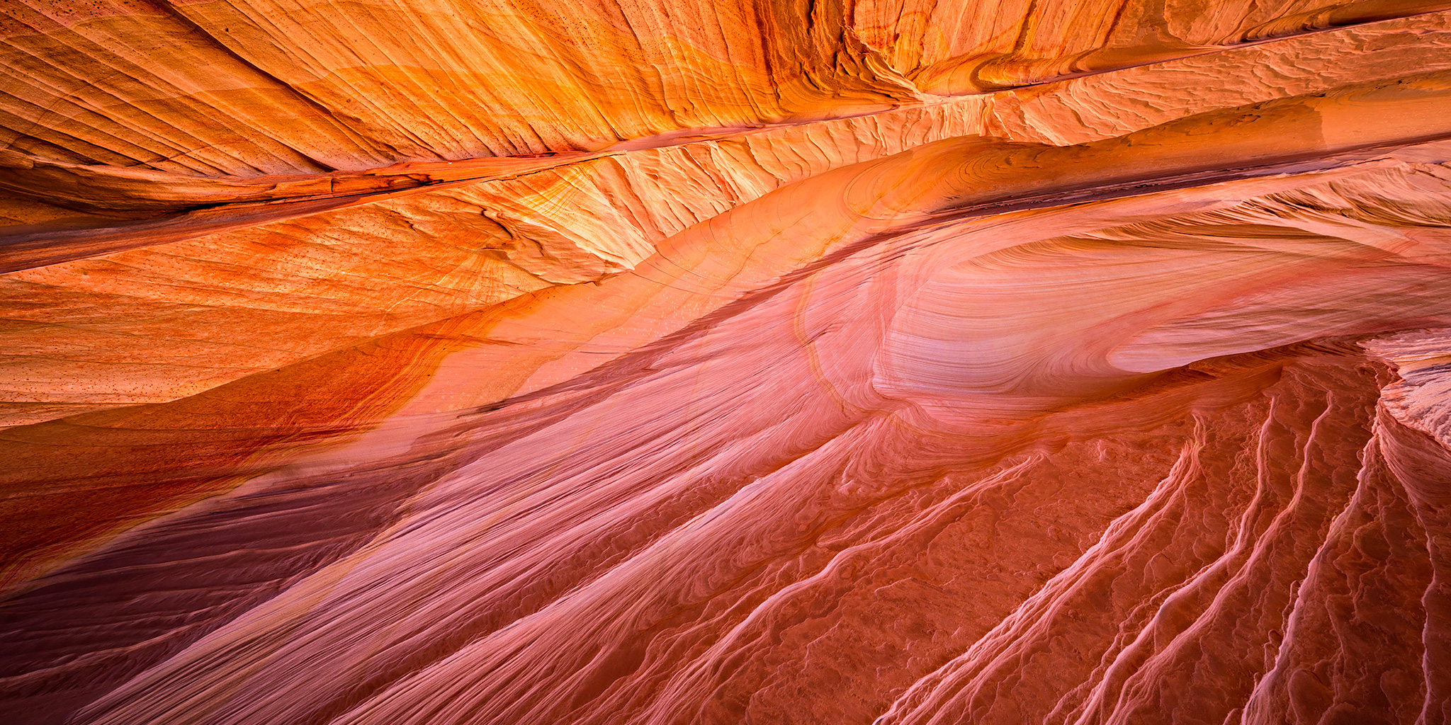
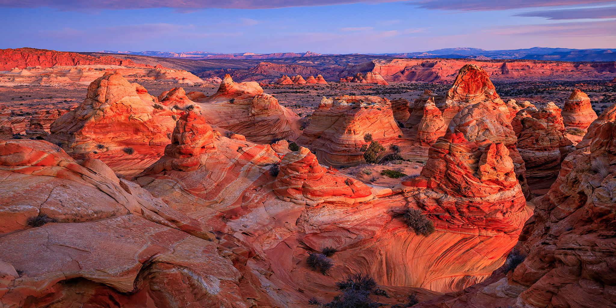
Arizona Strip & Southern Utah Wanderings | Day 3 Monday, October 8, 2012 On Monday morning we got up early and wandered over to The White Pocket again to catch the sunrise. We arrived plenty early to try and catch the pre-sunrise glow, which was amazing! There’s sometimes an amazing glow that really brings out [...]
Posts Tagged ‘vermilion cliffs national monument’
The Vermilion Cliffs to The Grand Staircase
Posted: October 8, 2012 by Randy Langstraat in Camping, Exploring, Four-Wheeling, Hiking, Jeeping, PhotographingTags: 2012, alpenglow, anasazi, arizona, arizona strip, camp, clouds, grand staircase, grand staircase - escalante national monument, house rock valley road, jeep, johnson canyon, kanab, lower pocket valley, nephi pasture road, petroglyphs, potsherds, poverty ranch, rock art, ruins, sand hills, sunrise, tent, utah, vermilion cliffs, vermilion cliffs national monument, white cliffs, white pocket, white pocket butte, wiregrass petroglyphs, wiregrass reservoir
Return to Coyote Buttes South
Posted: October 7, 2012 by Randy Langstraat in Camping, Exploring, Four-Wheeling, Hiking, Jeeping, PhotographingTags: 2012, anasazi, arizona, control tower, cottonwood cove, coyote buttes south, half and half, paria plateau, paw hole, petroglyphs, sandstone, south teepees, sunrise, sunset, the queen, totem pole, vermilion cliffs, vermilion cliffs national monument, yellow stripe
Arizona Strip & Southern Utah Wanderings | Day 2 Sunday, October 7, 2012 On Sunday we had permits to visit Coyote Buttes South. I spent a few hours in Coyote Buttes South back in February, but was looking forward to exploring more of the area today. We woke up extra early this morning so that [...]
An Evening at The White Pocket
Posted: October 6, 2012 by Randy Langstraat in Camping, Exploring, Four-Wheeling, Hiking, Jeeping, PhotographingTags: 2012, arizona, arizona strip, clouds, paria plateau, sunset, the swirl, twilight, vermilion cliffs, vermilion cliffs national monument, white pocket
Arizona Strip & Southern Utah Wanderings | Day 1 Saturday, October 6, 2012 On Saturday morning I left home to begin my annual fall trip to Southern Utah and the Arizona Strip. I met up with Jared in Moab so he could load his gear for the week into my Jeep and then we continued [...]
Annular Solar Eclipse & The Paria Plateau
Posted: May 20, 2012 by Randy Langstraat in Camping, Canyoneering, Exploring, Hiking, PhotographingTags: 2012, anasazi, annular solar eclipse, arches, arizona, basketmaker, bluff, bluff horses, buckskin gulch, buckskin wash, carrizo mountains, clouds, coyote buttes north, coyote wash, eclipse, la sal mountains, light, moon, navajo, new mexico, paria plateau, petroglyphs, racetrack, ring of fire, rock art, sand cove, sandstone, second wave, shadows, shiprock, slot canyon, solar eclipse, sun, sunset, the passage, the wave, utah, vermilion cliffs, vermilion cliffs national monument, vermilion cliffs wilderness, wilderness, wildflowers, wilson arch, wire pass
Friday – Sunday, May 18-20, 2012 A few months back I managed to get another pair of permits to the Coyote Buttes North area so that Amanda and I could visit The Wave again and explore a few new areas. It turns out that I had picked a great weekend to go without originally realizing [...]
Life & Death | Coyote Buttes North
Posted: February 12, 2012 by Randy Langstraat in Exploring, Hiking, PhotographingTags: 2012, arches, arizona, clouds, coyote buttes north, elephant trunk arch, melody arch, page, paria plateau, sand cove, sand dune alcove, second wave, the passage, the wave, top rock, top rock window, vermilion cliffs national monument, wire pass
Sunday, February 12, 2012 This trip report is dedicated in loving memory of my mom, Kathryn J. Langstraat. I’ve long been a believer of enjoying life and living it to the fullest. That’s why I’m out exploring the Colorado Plateau and Rocky Mountains just about every chance I get (and creating all of these trip [...]
Coyote Buttes South
Posted: February 11, 2012 by Randy Langstraat in Exploring, Hiking, Jeeping, PhotographingTags: 2012, arizona, control tower, cottonwood cove, coyote buttes south, half and half, page, paria plateau, vermilion cliffs national monument
Saturday, February 11, 2012 A few months back I scored another set of permits to Coyote Buttes North and The Wave. Since I was going to be down here for that, I decided to grab a pair of permits to Coyote Buttes South and make a weekend out of it. This was my first trip [...]
The Wave Weekend
Posted: November 6, 2011 by Randy Langstraat in Exploring, Hiking, Photographing, TouringTags: 2011, anasazi, arches, arizona, betatakin, california condor, colorado river, coyote buttes north, echo cliffs, glen canyon national recreation area, horseshoe bend, hot air balloons, jeep, lower antelope canyon, marble canyon, navajo bridges, navajo nation, navajo national monument, notch panel, page, page balloon regatta, petroglyphs, rock art, ruins, slot canyon, the wave, vermilion cliffs, vermilion cliffs national monument, vermilion cliffs wilderness
Friday-Sunday, November 4-6, 2011 The Wave, located just south of the Utah-Arizona state line in the Vermilion Cliffs Wilderness Area, is one of those places that every photographer and hiker wants to visit. It’s hard to blame them because it is such a unique and amazing area. Unfortunately, because of it’s popularity, the BLM has [...]
The White Pocket
Posted: October 6, 2011 by Randy Langstraat in Camping, Exploring, Hiking, Jeeping, PhotographingTags: 2011, anasazi, arches, arizona, arizona strip, buckskin wash, house rock valley road, jeep, notch panel, paria plateau, paw hole, petroglyphs, poverty flat, poverty ranch, rock art, sand cove, the cockscomb, vermilion cliffs national monument, white pocket
Arizona Strip & Southern Utah Wanderings | Day 6 Thursday, October 6, 2011 On Thursday we decided to take things easy again since we had another long hike planned for Friday. We didn’t really have any plans for the day, so over breakfast we brainstormed some ideas and decided to head over to the White [...]
