Press "Enter" to skip to content

Tag: tent

Mount Whitney: Top of the Contiguous USA

Friday – Tuesday, August 22-26, 2014

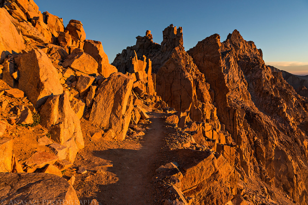
Mount Whitney- at 14,508 feet it is the highest mountain peak in the contiguous United States. While I have always thought about climbing to the summit of Mount Whitney at some point in my life, I really had never seriously planned a trip or time frame to do it. About two months ago my friend Geoff sent me a message and asked if I wanted to join him on a day hike of Mount Whitney. He had received a few permits in the lottery earlier in the year, but all of his hiking companions had cancelled on him. I checked my calendar and had no trips planned for that time yet, so I said yes. I figured since I had the opportunity come up that I might as well do it now, especially since I had already hiked six Colorado 14ers this year and was in pretty good shape. I was a little worried about doing the full 22 mile hike in a single day since I had never done a hike that long in one shot, especially with over 6,000 feet of elevation gain. I decided to keep an eye on the Mount Whitney permit website to see if any overnight permits opened up, and luckily a few weeks before the trip I was able to get two of them for the same time. I no longer had to worry about completing the hike in a single day and would be able to enjoy the trail more. Our plan was to backpack up to Trail Camp around 12,000 feet on Sunday and then finish the hike to the summit on Monday morning.

6 Comments

West Maroon Pass & Geneva Lake

Saturday & Sunday, August 9-10, 2014

Since Diane and I have been spending a lot of time this summer hiking in the San Juan Mountains I figured it was time to get in a weekend of hiking in the Elk Mountains, before it was too late. We left home bright and early on Saturday morning and drove around the Grand Mesa to Marble where we followed the Crystal River past the Crystal Mill and Devil’s Punchbowl towards Schofield Pass. Diane was not a fan of this narrow and rough road, especially when we drove over the sections of large moving rocks. We stopped at the trailhead in Schofield Park so we could start our hike up to West Maroon Pass. Unfortunately, driving over Schofield Pass took a little longer than I remembered, so we arrived later in the morning than I would normally like to start hiking during monsoon season in the mountains. Since we weren’t attempting to climb any peaks on this hike we decided to give it a shot and see what the weather would do. Some darker clouds moved into the sky early on during our hike and we got rained on a few times, but there were no thunderstorms nearby. While there were still plenty of flowers along it trail, it was obvious that wildflower season is definitely coming to and end as many of the flowers were wilted and dying. I bet this hike would have been an amazing sight a few weeks ago!

1 Comment

Blue Lakes in the Mount Sneffels Wilderness

Saturday & Sunday, August 2-3, 2014

This weekend Diane and I spent a nice relaxing overnight backpacking trip at the Blue Lakes in the Mount Sneffels Wilderness. I have wanted to hike up to the Blue Lakes for many years and am glad I was finally able to get up that way. The scenery was beautiful and the weather was nice all weekend, too. While it looked like we might receive some of the typical afternoon storms on Saturday, they managed to miss us and we never saw a drop of rain all weekend. There seemed to be quite a few bugs out this time of the year, especially near the large patches of wildflowers we came across, but we managed to keep the mosquitoes away with some DEET bug spray that seemed to work well. While there were a bunch of people camped on the northwest side of the lower lake when we arrived, we crossed the outlet creek and found a nice campsite on the northeast side where no one was camped. Only one other person ended up setting up camp on this side of the lake, so it was nice and quiet.

6 Comments

The Decalibron

Tuesday & Wednesday, July 29-30, 2014

The Decalibron is a name given to a route in the Mosquito Range that allows you to summit four of Colorado’s 58 named 14ers in one 7-mile loop; Mount Democrat (14,148 feet), Mount Cameron (14,238 feet), Mount Lincoln (14,286 feet) and Mount Bross (14,172 feet). Some people do not count Mount Cameron as an official 14er because it is not ranked (the saddle between Cameron and Lincoln does not drop below the 300 feet required), but I have decided that I am going to try and complete the list of named 14ers and am going to count it (why short myself some Colorado high points?). Since my goal for the year is to summit five 14ers, I figured that this hike would be a good way to reach that goal after hiking Huron Peak a few weeks ago. Since this route is very popular and closer to the Front Range (Denver area), it can be very busy on the weekends. I decided to avoid the crowds by taking a day off from work in the middle of the week to attempt this hike.

Leave a Comment

Red Rock to Black Canyon

Backpacking Red Rock Canyon
Saturday & Sunday, June 7-8, 2014

Deep, Steep and Narrow. That’s how the National Park Service describes the Black Canyon of the Gunnison, and it’s pretty accurate. The Black Canyon is comprised of some of the steepest cliffs, oldest rock, and craggiest spires in North America. I’ve wanted to hike down into the Black Canyon of the Gunnison for quite a while now and thought I would try Red Rock Canyon, the easiest route, for my first time. This trail is about 3.5 miles in length and only drops 1330 feet to the river. Compared to the other routes down to the Gunnison, this one is definitely the least steep.

4 Comments