Press "Enter" to skip to content

Tag: north fork

Otho Natural Bridge & Mill Creek Canyon

Moab Winter Weekend: Arch Hunting & Ancient Petroglyphs
Moab Area Rock Art XXXIV | Saturday & Sunday, December 21-22, 2019

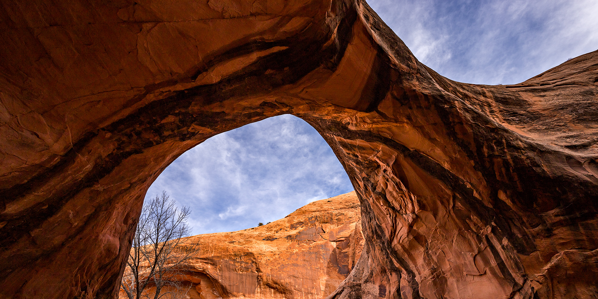
This weekend Diane and I headed over to Moab to search for arches and rock art, like we usually do at this time of the year. The weather can be unpredictable at the end of December, but we lucked out this weekend with comfortable hiking temperatures during the day and no snow or ice on the ground yet. I’ve wanted to visit Otho Natural Bridge for many years so I made that a priority this trip and we headed there first thing on Saturday morning. I had originally planned to hike up the North Fork of Mill Creek from the bottom to reach the arch, but we were stopped by a deep water crossing near the confluence of the two forks of Mill Creek. I had hiked this canyon before from the bottom without getting wet before, but it appears there are new beaver dams along the creek which have made that impossible now. We weren’t prepared to get wet this time in these temperatures, so we turned around and drove up into the Sand Flats Recreation Area to find another way down into the canyon instead. I’d never been up this far into this canyon before and the views and scenery were beautiful as we searched for a route into the canyon. I think I ended up liking this route into the canyon more than the one I had originally planned!

3 Comments

Mineral Point Peaks

Friday & Saturday, August 11-12, 2017

This weekend I headed down to the San Juan Mountains by myself to hike to the summit of a few mountains above the ghost town of Animas Forks near Mineral Point. I left after work on Friday afternoon and after a quick dinner in Montrose I drove over Red Mountain Pass to Silverton. From there I followed the Animas River to the base of Denver Hill (12,300) so I could go on a late evening hike to its summit. It was a short hike to the top, but it offered me some nice views of the surrounding mountains including Houghton Mountain (13,052), Seigal Mountain (13,274), Tuttle Mountain (13,203), Animas Forks Mountain (13,722), and Engineer Mountain (13,218). After hiking across the rolling tundra I reached PT 12340 which gave me a good overview of Mineral Point below and I caught a nice sunset on my way back to the Jeep.

Leave a Comment

La Plata Peak via the Southwest Ridge

Southwest Ridge | Saturday & Sunday, August 5-6, 2017

Last fall during my drive to the trailhead for Mount Elbert (14,433), I got a nice view of La Plata Peak as I was descending Independence Pass shortly before sunset and thought to myself that I should make time to climb that peak soon. That thought has stuck around in the back of my mind for the last year and I finally decided to make it happen this weekend since I had good luck with Culebra Peak (14,047) last weekend.

2 Comments

Wetterhorn Peak

Saturday & Sunday, August 22-23, 2015

Over the years I have spent a lot of time in and around the Uncompahgre Wilderness of the San Juan Mountains, and every time I do I usually see the massive Uncompahgre Peak looming above all the other mountains along with it’s shorter but more rugged neighbor, Wetterhorn Peak. I have wanted to climb Wetterhorn Peak for a long time, but the class 3 route to it’s summit combined with exposure had stopped me from trying until I gained more experience. For years I have looked at photos and videos of the final climb to the summit and thought that there was no way I’d be able to do that, so I kept putting it off. After a few years of hiking easier fourteeners, it was finally time for me to attempt my first class 3 route and I knew it would have to be on Wetterhorn.

4 Comments

West Maroon Pass & Geneva Lake

Saturday & Sunday, August 9-10, 2014

Since Diane and I have been spending a lot of time this summer hiking in the San Juan Mountains I figured it was time to get in a weekend of hiking in the Elk Mountains, before it was too late. We left home bright and early on Saturday morning and drove around the Grand Mesa to Marble where we followed the Crystal River past the Crystal Mill and Devil’s Punchbowl towards Schofield Pass. Diane was not a fan of this narrow and rough road, especially when we drove over the sections of large moving rocks. We stopped at the trailhead in Schofield Park so we could start our hike up to West Maroon Pass. Unfortunately, driving over Schofield Pass took a little longer than I remembered, so we arrived later in the morning than I would normally like to start hiking during monsoon season in the mountains. Since we weren’t attempting to climb any peaks on this hike we decided to give it a shot and see what the weather would do. Some darker clouds moved into the sky early on during our hike and we got rained on a few times, but there were no thunderstorms nearby. While there were still plenty of flowers along it trail, it was obvious that wildflower season is definitely coming to and end as many of the flowers were wilted and dying. I bet this hike would have been an amazing sight a few weeks ago!

1 Comment