Press "Enter" to skip to content

Tag: map

No Thoroughfare Canyon Loop

Saturday, October 24, 2015

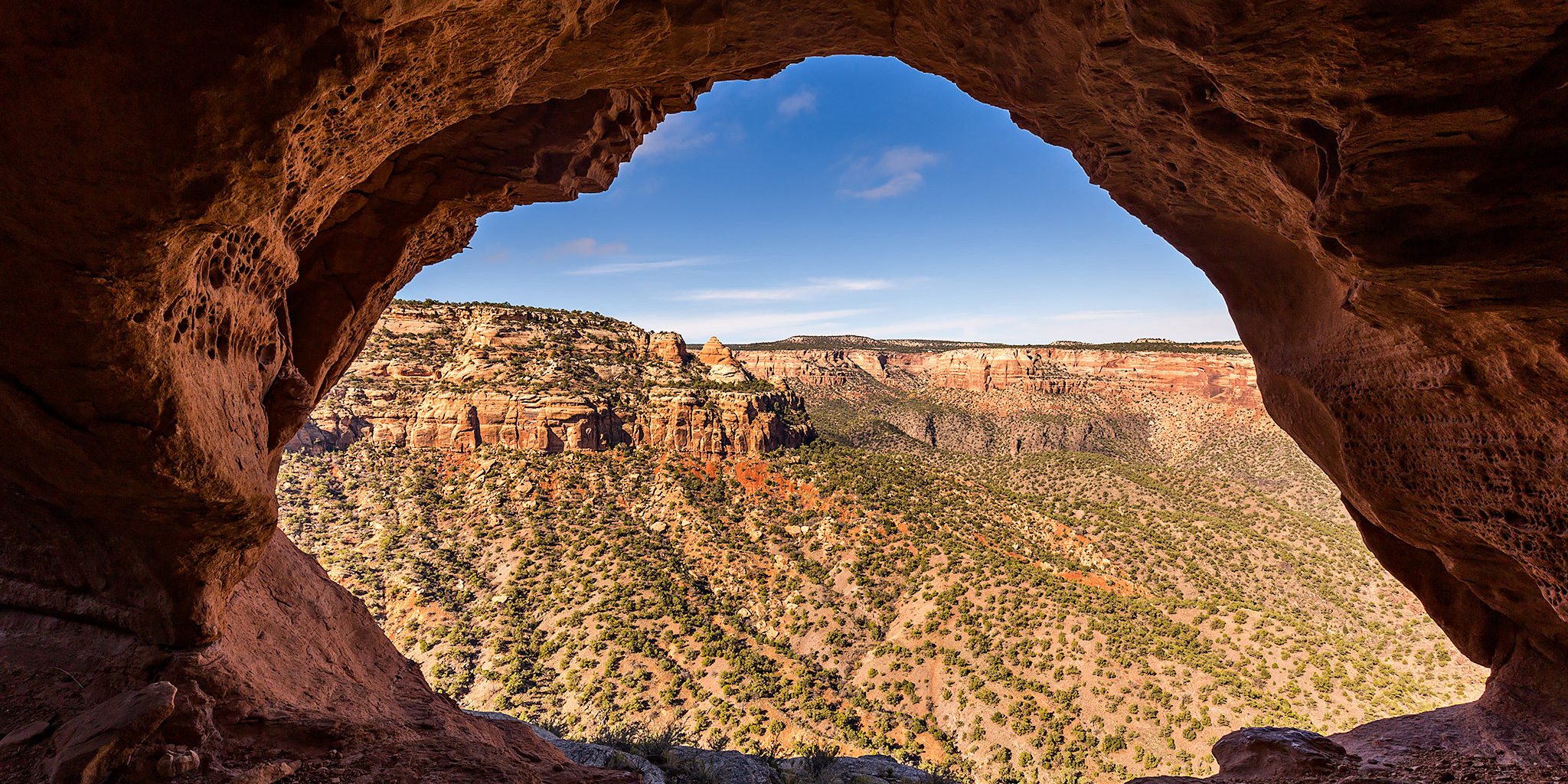
This morning I went on a new hike in the Colorado National Monument with Jackson and Chris from work. Our plan was to create a loop that combined parts of the No Thoroughfare Canyon Trail and the Old Gordon Trail while visiting a little-known arch along the way. We would connect the two trails up by hiking up a short side-canyon and then scrambling up a steep gully behind the arch to the rim of the canyon. This route ended up creating a nice seven mile loop through the backcountry and visited Windowpane Arch (No Thoroughfare Window) and the remains of an old cabin. It was a great morning for a hike, minus the excessive humidity we had to deal with.

2 Comments

Abrams Mountain & Cimarron Thirteeners

Saturday & Sunday, September 19-20, 2015

On my quest to hike and explore more of the Uncompahgre Wilderness I decided to climb a pair of thirteeners in The Cimarrons along the high ridge that towers between the West Fork and the Middle Fork of the Cimarron River. The peaks along this ridge are prominent landmarks on the horizon every time I drive south into the San Juan Mountains and it was time to finally get a closer look.

3 Comments

San Luis Peak in the La Garita Mountains

Saturday & Sunday, September 12-13, 2015

Since Diane needed to stay home this weekend to get some school work done, I was on my own and decided to climb my sixth and final new fourteener of the year. After looking over my maps I settled on hiking to the summit of San Luis Peak (14,014) in the La Garita Mountains near Creede. Instead of taking the standard route up Stewart Creek from the northeast, I chose to follow the Continental Divide Trail north of Creede to the south ridge. Not only is this route a little shorter, I also thought the views along the Continental Divide would be better. Plus, I had never really stopped in Creede before and thought this would be a good opportunity to check out the area.

Leave a Comment

Big Blue Creek

Labor Day Weekend | Saturday – Monday, September 5-7, 2015

This year for the long Labor Day weekend I wanted to go on another backpacking trip into the Uncompahgre Wilderness of Colorado’s San Juan Mountains, but I also wanted to go somewhere that was unlikely to be crowded since this is probably one of the busiest camping weekends of the year. After some research I selected the Big Blue Creek drainage as our destination. Not only was there very little information about this area online and in guides, which hopefully meant it wouldn’t be very crowded, but I was also hoping to photograph the north face of Uncompahgre Peak (14,309) at sunrise since I hadn’t seen too many photos of this massive mountain from that side. I had originally thought about connecting the Fall Creek and Failes Creek trails to create a big loop hike but changed that idea so that I would be able to spend two mornings photographing Uncompahgre Peak to help improve my chances of catching a great sunrise.

2 Comments

Twin Peaks

Saturday, June 13, 2015

This morning I drove down to Ouray so I could try and climb my first mountain summit of the year. After this weekend I’m going to be pretty busy for the rest of June and I didn’t want to wait until July to get into the mountains for the first time this year. Since I’m not in the best shape right now and the weather forecast was predicting that storms would move into the area late in the morning, I decided to hike to the top of Twin Peaks (10,798 feet), a famous Ouray landmark. There are currently two trails that will get you to the summit- a new trail and an old trail. The reason for this is because in the early 1980’s the Old Twin Peaks Trail was washed out by a major storm. To replace the old trail, a new connector from the Oak Creek Trail was built to bypass the washed out section. This trail is now known as the New Twin Peaks Trail. In 2004 the Ouray Trails Group reconstructed the old trail which now consists of over 300 steps and 1,300 feet of elevation gain within 1.2 miles. Apparently, the Forest Service won’t officially sanction the reconstructed trail because they consider it too steep, but it is back on the maps.

1 Comment